IMAGES TAKEN NEAR TO
Oak Lane, ISLEWORTH, TW7 6HH
Introduction
This page details the photographs taken nearby to Oak Lane, TW7 6HH by members of the Geograph project.
The Geograph project started in 2005 with the aim of publishing, organising and preserving representative images for every square kilometre of Great Britain, Ireland and the Isle of Man.

There are currently over 7.5m images from over14,400 individuals and you can help contribute to the project by visiting https://www.geograph.org.uk
Image Map
Images are licensed for reuse under creativecommons.org/licenses/by-sa/2.0
Notes
- Clicking on the map will re-center to the selected point.
- The higher the marker number, the further away the image location is from the centre of the postcode.
Image Listing (16 Images Found)
Images are licensed for reuse under creativecommons.org/licenses/by-sa/2.0
Image
Details
Distance

2
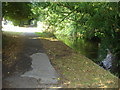
Riverside Walk, Isleworth
The Duke of Northumberland's river
Image: © David Howard
Taken: 8 Aug 2010
0.06 miles
3
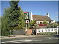
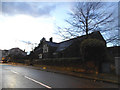
The Royal Oak, Worton Road, Isleworth
One of many pubs which refer to the English oak tree within which the future King Charles II hid to escape the Roundheads following the Battle of Worcester in 1651. The pub sign features the head of Charles within the tree. The photograph is taken from the bridge over the Duke of Northumberland's River.
Image: © Marathon
Taken: 20 Oct 2010
0.07 miles
4

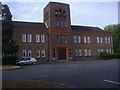
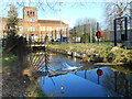
1930s Architecture, Mogden STW
Mogden Sewage Treatment Works was laid out by Middlesex County Council in the early 1930s. The impressive office building at the centre of the works compares favourably with the shabby blocks at many utility sites.
Image: © Des Blenkinsopp
Taken: 8 Jan 2019
0.14 miles
5

Explaining the Sewage Works
A footpath and cycleway goes through the middle of Thames Water's Mogden Sewage Treatment Works which is one of the largest in the country. A visitor board is beside the path in front of the works office building from the 1930s when the site was constructed by Middlesex County Council.
https://en.wikipedia.org/wiki/Mogden_Sewage_Treatment_Works
Image: © Des Blenkinsopp
Taken: 8 Jan 2019
0.16 miles
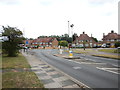
9
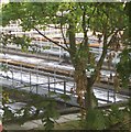
Gauging Weir on the Duke's River
The Duke of Northumberland's River was dug in Tudor times to supply Syon Park House and mills in Isleworth. Seen here in the middle of Mogden Sewage works.
"Built in 1931–36 by Middlesex County Council and now operated by Thames Water, Mogden is one of the largest sewage works in the United Kingdom. It treats the waste water from about 1.9 million people served by three sewers in North and West London. The plant has been extended and upgraded several times, most recently in 2011–13, and now covers 55 hectares." https://en.wikipedia.org/wiki/Mogden_Sewage_Treatment_Works
Image: © Des Blenkinsopp
Taken: 8 Jan 2019
0.20 miles
10
Mogden Water Treatment Plant
Mogden sewage works are very much a local landmark though the smell is more present than the view.
Image: © Helene
Taken: 27 Jun 2005
0.24 miles