IMAGES TAKEN NEAR TO
London Road, ISLEWORTH, TW7 5XG
Introduction
This page details the photographs taken nearby to London Road, TW7 5XG by members of the Geograph project.
The Geograph project started in 2005 with the aim of publishing, organising and preserving representative images for every square kilometre of Great Britain, Ireland and the Isle of Man.

There are currently over 7.5m images from over14,400 individuals and you can help contribute to the project by visiting https://www.geograph.org.uk
Image Map
Images are licensed for reuse under creativecommons.org/licenses/by-sa/2.0
Notes
- Clicking on the map will re-center to the selected point.
- The higher the marker number, the further away the image location is from the centre of the postcode.
Image Listing (25 Images Found)
Images are licensed for reuse under creativecommons.org/licenses/by-sa/2.0
Image
Details
Distance
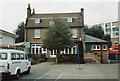
6
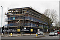
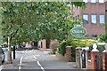
The Syon
Residential development, close to Syon Park.
Image: © Peter Trimming
Taken: 16 Apr 2016
0.06 miles
7
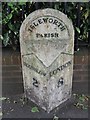
Old Milepost by the A315, London Road, Isleworth
Cast iron post by the A315, in parish of HOUNSLOW (HOUNSLOW District), London Road; Isleworth, Milestone Court, East of junction with Teesdale Avenue, by wall/railing in footpath, on South side of road. Middlesex cast iron, erected by the Kensington to Cranford Bridge turnpike trust in the 19th century.
Inscription reads:-
: HOUNSLOW / 2 : : ISLEWORTH / PARISH : : LONDON / 8 :
Grade II listed.
List Entry Number: 1390545 https://historicengland.org.uk/listing/the-list/list-entry/1390545
Milestone Society National ID: MX_LB08.
Image: © A Rosevear
Taken: 8 Jun 2002
0.07 miles
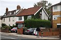
8
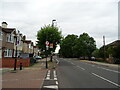
Twickenham Road at the junction with London Road
Image: © David Howard
Taken: 8 Nov 2018
0.08 miles
9
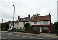
Busch House School, July 1982
A view of Busch House from the school playground. The house is a Georgian mansion, and is Grade 2 listed. The school used the ground floor as an assembly and dining hall, while the upper floors were the caretaker's accommodation. The single storey extension on the right is the school kitchen. The minibus was not usually parked on the playground, but this was holiday time, and the vehicle had been moved for security reasons.
See also: Image
Image: © Richard Dorrell
Taken: Unknown
0.09 miles
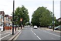
10
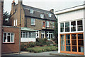
Busch House School, July 1982
At the time this photograph was taken, Busch House School was a Local Authority Special School for pupils with emotional and behavioural difficulties. There were about 70 pupils on roll aged from 5 to 16. The school opened in 1938 as an Open Air School for delicate children. The school was housed in several wooden buildings which had large folding windows which could be fully opened to create 'open air' classrooms. The corner of one of the buildings is visible on the right. In 1982, this room was the Gym. The large building is Busch House, which is a small Georgian mansion, and is Grade 2 listed. The school used the ground floor as an assembly and dining hall. The upper floors were the caretaker's accommodation. The conservatory was used as a staff dining room and for individual tuition. The brick building on the left is the corner of the admin block, which contained offices and staff room. Busch House from the road: Image
Image: © Richard Dorrell
Taken: Unknown
0.09 miles