IMAGES TAKEN NEAR TO
Syon Lane, ISLEWORTH, TW7 5PU
Introduction
This page details the photographs taken nearby to Syon Lane, TW7 5PU by members of the Geograph project.
The Geograph project started in 2005 with the aim of publishing, organising and preserving representative images for every square kilometre of Great Britain, Ireland and the Isle of Man.

There are currently over 7.5m images from over14,400 individuals and you can help contribute to the project by visiting https://www.geograph.org.uk
Image Map
Images are licensed for reuse under creativecommons.org/licenses/by-sa/2.0
Notes
- Clicking on the map will re-center to the selected point.
- The higher the marker number, the further away the image location is from the centre of the postcode.
Image Listing (38 Images Found)
Images are licensed for reuse under creativecommons.org/licenses/by-sa/2.0
Image
Details
Distance
1
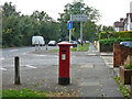
Junction of Gower Road and Syon Lane
The postbox number is TW7 283.
Image: © Robin Webster
Taken: 9 Sep 2012
0.05 miles
2
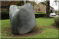
Bronze at Brentford
Located on Syon Lane, at the junction with Stags Way.
Image: © Peter Trimming
Taken: 16 Apr 2016
0.08 miles
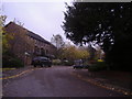
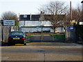
3
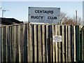
Gower Road Gate entrance to Centaurs RFC stadium
Image: © J Taylor
Taken: 25 Nov 2008
0.09 miles
4
View from Centaurs RFC stadium - looking towards Gower Road entrance
Image: © J Taylor
Taken: 25 Nov 2008
0.09 miles
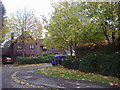
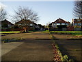
7
Stags Way, Osterley
A modern development on the edge of Osterley Park
Image: © David Howard
Taken: 3 Nov 2008
0.12 miles
8
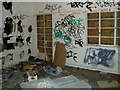
Centaurs RFC stadium - vandalised interior
This is the upper northwards room
Image: © J Taylor
Taken: 25 Nov 2008
0.12 miles
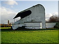
9
Rear view of Centaurs RFC stadium - view from Gower Road
Image: © J Taylor
Taken: 25 Nov 2008
0.12 miles
10
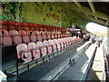
Centaurs RFC stadium - seats looking northwards
Image: © J Taylor
Taken: 25 Nov 2008
0.12 miles