IMAGES TAKEN NEAR TO
Jersey Road, ISLEWORTH, TW7 5PL
Introduction
This page details the photographs taken nearby to Jersey Road, TW7 5PL by members of the Geograph project.
The Geograph project started in 2005 with the aim of publishing, organising and preserving representative images for every square kilometre of Great Britain, Ireland and the Isle of Man.

There are currently over 7.5m images from over14,400 individuals and you can help contribute to the project by visiting https://www.geograph.org.uk
Image Map
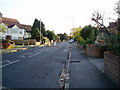
Images are licensed for reuse under creativecommons.org/licenses/by-sa/2.0
Notes
- Clicking on the map will re-center to the selected point.
- The higher the marker number, the further away the image location is from the centre of the postcode.
Image Listing (57 Images Found)
Images are licensed for reuse under creativecommons.org/licenses/by-sa/2.0
Image
Details
Distance
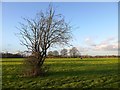
2
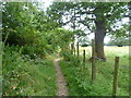
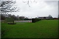
Footpath along the edge of Osterley Park
Osterley Park and its surrounding gardens, park and farmland is one of the last surviving country estates in London.
In 1565, Sir Thomas Gresham, financier and adviser to Elizabeth I, built a house here in a very similar location to the one today. In 1713, the Osterley estate was acquired by the Child family and in the 1760s they commissioned Robert Adam to remodel it. The Childs were a banking family with a house in central London, and they used Osterley as a country villa for entertaining. When the heiress Sarah Sophia Child married the 5th Earl of Jersey in 1804, the family moved to the Jersey estate at Middleton Park in Oxfordshire. Osterley remained in the Jersey family ownership until the Ninth Earl of Jersey gave it to the National Trust in 1949.
Apart from the more formal ground and lake surrounding the house, there are a number of footpaths through the surrounding parkland as seen here. The back gardens of the houses in Jersey Road are to the left. Walking routes are only accessible during the Park's opening times which are winter 8 - 6pm and summer 8 - 7.30pm.
Image: © Marathon
Taken: 16 Jul 2014
0.05 miles
3
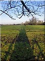
Low sun, long shadows: Osterley in January
This is the south-east corner of the Osterley Park estate, an area grazed by horses. Some years ago, cattle were regularly pastured here - these days they are to be seen a little further north, nearer the motorway,
The photo was taken on what turned out to be the second really sunny day of 2011.
Image: © Stefan Czapski
Taken: 18 Jan 2011
0.05 miles
4
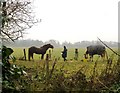
Feeding the horses, Osterley Park
A misty day in mid-winter. The horses are being fed in a paddock on the south-east side of the park, near Wyke Green. This looks just like the countryside - but within ten minutes' walk from here you can be on the Piccadilly Line.
Image: © Stefan Czapski
Taken: 30 Dec 2010
0.06 miles
6
Wycombe House Club
These are the Wycombe House Club tennis courts in Osterley. Cricket is also played here.
Image: © Glyn Baker
Taken: 31 Dec 2006
0.07 miles
7
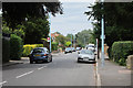
Wood Lane (junction with Jersey Road) Osterley, Hounslow
The plane in the sky is on the approach path to Heathrow Airport
Image: © J Taylor
Taken: 11 Nov 2008
0.09 miles
8
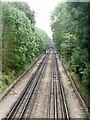
Westbound Piccadilly Line from Syon Lane bridge
The bridge in view carries Wood Lane.
Image: © Robin Webster
Taken: 9 Sep 2012
0.10 miles
9
Pasture land in early February, Osterley Park Farm
Up till about 15 years ago this area was regularly grazed by the local herd of cattle. These days the entire (substantial) acreage seems to be occupied by horses.
Photo taken from the narrow (and fenced) path that runs along the southern and eastern boundaries of Osterley Park between Wyke Green and the avenue south of the house.
Image: © Stefan Czapski
Taken: 2 Feb 2016
0.10 miles
10
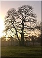
Sweet chestnut tree in January, Osterley Park
Photo taken on a cloudless but chilly January afternoon. The trees in the distance are part of the main approach avenue to Osterley Park House.
Image: © Stefan Czapski
Taken: 2 Jan 2015
0.10 miles