IMAGES TAKEN NEAR TO
Wood Lane, ISLEWORTH, TW7 5EQ
Introduction
This page details the photographs taken nearby to Wood Lane, TW7 5EQ by members of the Geograph project.
The Geograph project started in 2005 with the aim of publishing, organising and preserving representative images for every square kilometre of Great Britain, Ireland and the Isle of Man.

There are currently over 7.5m images from over14,400 individuals and you can help contribute to the project by visiting https://www.geograph.org.uk
Image Map
Images are licensed for reuse under creativecommons.org/licenses/by-sa/2.0
Notes
- Clicking on the map will re-center to the selected point.
- The higher the marker number, the further away the image location is from the centre of the postcode.
Image Listing (34 Images Found)
Images are licensed for reuse under creativecommons.org/licenses/by-sa/2.0
Image
Details
Distance
1
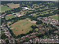
The Conquest Club from the air
A disused sports field off Syon Lane which was also the site of an IBM Clubhouse.
Image: © Thomas Nugent
Taken: 10 Aug 2016
0.03 miles

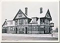
3
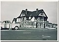
Osterley Hotel.
Photographed in the Summer of 1958, when traffic was much quieter. Note the older type traffic lights, the original pub sign and the uncluttered appearance around the building. Oh! and that's a Ford Consul which just happened to get in the way.
Image: © Clive Warneford
Taken: Unknown
0.07 miles
4
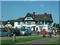
Pillar to Post, Wood Lane, Isleworth
Image: © Alexander P Kapp
Taken: 22 Jul 2012
0.07 miles
6
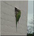
Osterley Parakeet sniffing air-vent
The parakeet is more likely to be foraging for food. This is a feral ring-necked parakeet - scientific name Psittacula krameri.
Image: © pete traill
Taken: 9 Feb 2005
0.07 miles
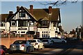
7
Osterley Hotel.
Osterley Hotel, on the corner of Wood Lane & The Great West Road on a Winters day in 1956. Crates out the front indicate that this was a Brewery day when a Trumans lorry would arrive to deliver fresh supplies of draught beer and crates of bottled beers. A hatch was located in front of the nearest corner window, which when opened up allowed the barrels to be lowered down to the cellars.
Image: © Clive Warneford
Taken: Unknown
0.08 miles
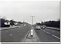
9
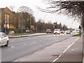
The Great West Road at Osterley: view west
View west towards Heathrow, in rain.
The urban fabric hereabouts is mainly between-the-wars residential development. At about the same time there was industrial ribbon development further east - giving rise (amongst others) to the Gillette and Firestone Tyre factories.
Image: © Stefan Czapski
Taken: 28 Feb 2017
0.08 miles
10
Great West Road at Osterley.
Viewed looking towards London, one can just make out Gillette's clock tower on left hand side over the roof of the Osterley Hotel and on the right hand side the roof of St.Francis Church. Note that there are cycle tracks on each side of the carriageway, grass verges, very few street lights and not much traffic!
The houses on the left are part of a small development known as Leigham Drive, accessed by the service road, running parallel to the main road. Borough Road Teachers Training College is behind the hedgerow on the right.
Image: © Clive Warneford
Taken: Unknown
0.09 miles