IMAGES TAKEN NEAR TO
Thornbury Road, ISLEWORTH, TW7 4QG
Introduction
This page details the photographs taken nearby to Thornbury Road, TW7 4QG by members of the Geograph project.
The Geograph project started in 2005 with the aim of publishing, organising and preserving representative images for every square kilometre of Great Britain, Ireland and the Isle of Man.

There are currently over 7.5m images from over14,400 individuals and you can help contribute to the project by visiting https://www.geograph.org.uk
Image Map
Images are licensed for reuse under creativecommons.org/licenses/by-sa/2.0
Notes
- Clicking on the map will re-center to the selected point.
- The higher the marker number, the further away the image location is from the centre of the postcode.
Image Listing (167 Images Found)
Images are licensed for reuse under creativecommons.org/licenses/by-sa/2.0
Image
Details
Distance
1
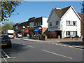
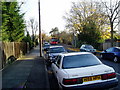
Shops on Thornbury Road
This parade of shops near St Mary's Crescent included, from right to left as of 2011, a dental practice, convenience store, takeaway, newsagent, launderette, cafe, and two other retail units (not identifiable in the photo).
Image: © Stephen Craven
Taken: 9 Apr 2011
0.02 miles
2
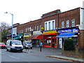
Shops on Thornbury Road
At the junction of St Marys Crescent.
Image: © Thomas Nugent
Taken: 8 Nov 2011
0.02 miles
3
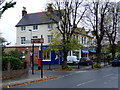
Shops on Thornbury Road
At the junction with Osterley Avenue.
Image: © Thomas Nugent
Taken: 8 Nov 2011
0.02 miles
4
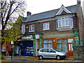
Estate agent on Thornbury Road
Opposite the former Osterley railway station.
Image: © Thomas Nugent
Taken: 8 Nov 2011
0.03 miles
5
Thornbury Road at junction with Jersey road, Osterley, Hounslow
The bus is H28 - (Dennis Dart SLF 8.8m /Plaxton Pointer 2)
Its route is from Bulls Bridge Tesco to Osterley Tesco
Via Cranford, Heston, Hounslow, Lampton, Isleworth
Distant 11 miles (18 km)
Frequency About every 20-30 minutes
Journey time 47-75 minutes
Day 7:00am until 0:00am (No night service)
Image: © J Taylor
Taken: 11 Nov 2008
0.03 miles
6
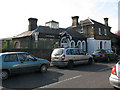
Former station buildings, Thornbury Road
The buildings shown here were the station buildings of the original "Osterley and Spring Grove" station on the District Railway, opened in 1883 and superseded in 1934 by the present Osterley station (in the same grid square) on the A4 main road, when the route became the Piccadilly Line of London Transport. One of the buildings is currently a bookshop.
Image: © Stephen Craven
Taken: 9 Apr 2011
0.03 miles
7
Former Osterley station
On Thornbury Road.
Image: © Thomas Nugent
Taken: 8 Nov 2011
0.03 miles
8
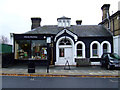
Osterley Bookshop
In the former Osterley railway station on Thornbury Road.
Image: © Thomas Nugent
Taken: 8 Nov 2011
0.03 miles
9
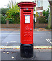
GR postbox
On Osterley Avenue at Thornbury Road.
Image: © Thomas Nugent
Taken: 8 Nov 2011
0.03 miles
10
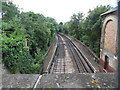
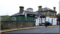
Former Osterley & Spring Grove Station
Situated in Thornbury Road TW7 4QE, this former station on the Piccadilly Line was opened on Tuesday 1st May 1883 and closed on Saturday 24th March 1934. The replacement station OSTERLEY was opened the following day it being located approximately 300metres south west on the A4 Great West Road, TQ 1477 refers. Remains of the former station building can be seen to the right of the photo whilst the former platforms can be seen on each side of the tracks.
Image: © David Hillas
Taken: 14 Jul 2016
0.03 miles