IMAGES TAKEN NEAR TO
Worton Way, ISLEWORTH, TW7 4AX
Introduction
This page details the photographs taken nearby to Worton Way, TW7 4AX by members of the Geograph project.
The Geograph project started in 2005 with the aim of publishing, organising and preserving representative images for every square kilometre of Great Britain, Ireland and the Isle of Man.

There are currently over 7.5m images from over14,400 individuals and you can help contribute to the project by visiting https://www.geograph.org.uk
Image Map
Images are licensed for reuse under creativecommons.org/licenses/by-sa/2.0
Notes
- Clicking on the map will re-center to the selected point.
- The higher the marker number, the further away the image location is from the centre of the postcode.
Image Listing (70 Images Found)
Images are licensed for reuse under creativecommons.org/licenses/by-sa/2.0
Image
Details
Distance
3
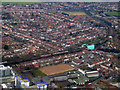
Hounslow from the air
The distinctive shape and colour of Hounslow East station Image can be seen to the right of centre.
Image: © Thomas Nugent
Taken: 24 Jan 2011
0.14 miles
4
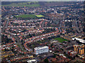
Hounslow from the air
The Piccadilly tube line can be seen to the top left. The distinctive building in the foreground is on London Road.
Image: © Thomas Nugent
Taken: 24 Jan 2011
0.14 miles
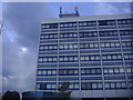
7
Office block on London Road, Isleworth
Image: © David Howard
Taken: 25 Jan 2014
0.15 miles
9
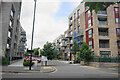
Apartment block complex on London Road
Described as 632-654 London Road. Silchester Apartments are the largest constituent.
Image: © Bill Boaden
Taken: 26 May 2022
0.16 miles
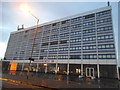
10
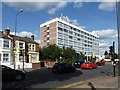
Office block on London Road, 2012
Now demolished and replaced with flats.
Image: © Robin Webster
Taken: 22 Sep 2012
0.16 miles