IMAGES TAKEN NEAR TO
Keysham Avenue, HOUNSLOW, TW5 9RB
Introduction
This page details the photographs taken nearby to Keysham Avenue, TW5 9RB by members of the Geograph project.
The Geograph project started in 2005 with the aim of publishing, organising and preserving representative images for every square kilometre of Great Britain, Ireland and the Isle of Man.

There are currently over 7.5m images from over14,400 individuals and you can help contribute to the project by visiting https://www.geograph.org.uk
Image Map
Images are licensed for reuse under creativecommons.org/licenses/by-sa/2.0
Notes
- Clicking on the map will re-center to the selected point.
- The higher the marker number, the further away the image location is from the centre of the postcode.
Image Listing (75 Images Found)
Images are licensed for reuse under creativecommons.org/licenses/by-sa/2.0
Image
Details
Distance
3
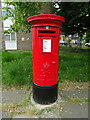
Elizabeth II postbox on High Street, Cranford
Postbox No. TW5 7.
Image: © JThomas
Taken: 23 May 2022
0.06 miles
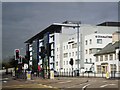
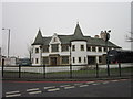
5
Doubletree by Hilton Hotel
The older part, a big modern block is to the left. This older part was formerly the Berkeley Arms Hotel.
Image: © Robin Webster
Taken: 22 Sep 2012
0.07 miles
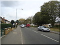
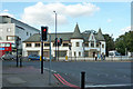
8
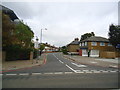
A4 Bath Road, heading east
At Waye Avenue bus stop. Waye Avenue is across the road with pedestrian lights just behind the camera to get to it.
Image: © Robin Webster
Taken: 22 Apr 2018
0.08 miles