IMAGES TAKEN NEAR TO
High Street, HOUNSLOW, TW5 9PF
Introduction
This page details the photographs taken nearby to High Street, TW5 9PF by members of the Geograph project.
The Geograph project started in 2005 with the aim of publishing, organising and preserving representative images for every square kilometre of Great Britain, Ireland and the Isle of Man.

There are currently over 7.5m images from over14,400 individuals and you can help contribute to the project by visiting https://www.geograph.org.uk
Image Map
Images are licensed for reuse under creativecommons.org/licenses/by-sa/2.0
Notes
- Clicking on the map will re-center to the selected point.
- The higher the marker number, the further away the image location is from the centre of the postcode.
Image Listing (22 Images Found)
Images are licensed for reuse under creativecommons.org/licenses/by-sa/2.0
Image
Details
Distance
1
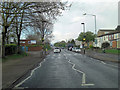
Cranford High Street passes Cranford Community College
Image: © Stuart Logan
Taken: 12 Apr 2012
0.05 miles
2

Redwood Estate Flats
The roads are also called Redwood estate.
Image: © James Emmans
Taken: 22 Aug 2016
0.10 miles
3

Cranford Community College
The college is bounded by two major roads: the M4 (top right) and the A312 (emerging from bottom of photo).
Taken from a departing British Airways flight BA1394 to Manchester from runway 09R.
Image: © Richard Cooke
Taken: 24 Nov 2016
0.13 miles
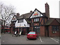
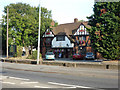
7
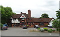
The Queens Head, Cranford
On High Street.
See Image] for sign.
Image: © JThomas
Taken: 23 May 2022
0.15 miles
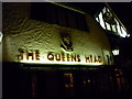
8
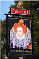
The Queens Head - inn sign
For the rest of the pub, see Image
Image: © Robin Webster
Taken: 22 Sep 2012
0.15 miles
9
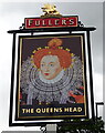
Sign for the Queens Head, Cranford
See Image] for public house.
Image: © JThomas
Taken: 23 May 2022
0.15 miles
10
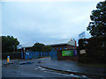
The entrance to Cranford Community College on the High Street
Image: © David Howard
Taken: 13 Oct 2013
0.16 miles