IMAGES TAKEN NEAR TO
Watersplash Lane, HOUNSLOW, TW5 9HN
Introduction
This page details the photographs taken nearby to Watersplash Lane, TW5 9HN by members of the Geograph project.
The Geograph project started in 2005 with the aim of publishing, organising and preserving representative images for every square kilometre of Great Britain, Ireland and the Isle of Man.

There are currently over 7.5m images from over14,400 individuals and you can help contribute to the project by visiting https://www.geograph.org.uk
Image Map
Images are licensed for reuse under creativecommons.org/licenses/by-sa/2.0
Notes
- Clicking on the map will re-center to the selected point.
- The higher the marker number, the further away the image location is from the centre of the postcode.
Image Listing (16 Images Found)
Images are licensed for reuse under creativecommons.org/licenses/by-sa/2.0
Image
Details
Distance
1
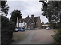
Old Vicarage - Church Road
Now used as a nursery.
Image: © James Emmans
Taken: 22 Aug 2016
0.04 miles
2
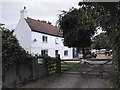
Farmhouse on Church Road
Lower Park Farm
Image: © James Emmans
Taken: 22 Aug 2016
0.04 miles

4
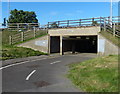
Cycleway and footpath passing under the A312
Image: © Mat Fascione
Taken: 21 Aug 2015
0.15 miles
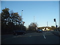
5
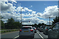
Last traffic lights before the M4, heading south on the A312
Image: © Rob Purvis
Taken: 6 Aug 2017
0.16 miles
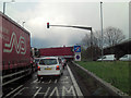
6
Roundabout on Parkway, Harlington
At the junction of the M4 motorway
Image: © David Howard
Taken: 9 Nov 2014
0.16 miles
7
The reality of the rush hour
The roundabout is obscurved by the vehicles going around it.
Image: © Stuart Logan
Taken: 12 Apr 2012
0.18 miles
8
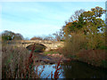
Bridge to Cranford Park
The same scene as Image almost exactly 3 years later. The photographer says the river then was in a disgraceful state, which happily is no longer the case, at least not in the country park.
Further downstream it is sadly still true, with accumulations of garbage, mainly floating bottles and cans, blocking the stream at regular intervals.
Image: © Des Blenkinsopp
Taken: 25 Nov 2011
0.19 miles
9
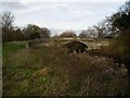
Bridge over the River Crane leading to Cranford Park
The river Crane is full of rubbish and is an utter disgrace
Image: © J Taylor
Taken: 19 Nov 2008
0.20 miles
10
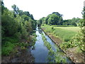
River Crane in Cranford Park
Cranford House was the seat of the Berkeleys up until the end of the 19th century. The early Georgian mansion was demolished in 1945 at the end of the Second World War which was about the time that the park came into public ownership. The 18th century stable and barn block survive, as do the cellars of the old house, and the old parish church of Cranford. St Dunstan's Church dates from the 15th and 17th centuries and is approached through a lych gate by the stable block. There is also a ha-ha, a large walled garden, the site of an ice house, and some ancient woodland.
This straight section of the River Crane, along the eastern edge of the park, originally formed part of an ornamental canal, in the formal rectangular style of the lake at Hampton Court. The path is followed by the London LOOP - see https://www.geograph.org.uk/photo/5799301
The source of the River Crane is the Yeading Brook at Pinner. This becomes the River Crane near the Grand Union Canal in Hayes.
The Crane then runs south here through Cranford Park, follows the eastern perimeter of Heathrow Airport and then past Hounslow Heath to head eastwards towards Whitton and Twickenham and then north-east through St Margarets, joining the Thames at Isleworth. See http://www.londonslostrivers.com/river-crane.html for maps, photographs and more information.
Image: © Marathon
Taken: 6 Jun 2018
0.22 miles