IMAGES TAKEN NEAR TO
Springwell Road, HOUNSLOW, TW5 9EQ
Introduction
This page details the photographs taken nearby to Springwell Road, TW5 9EQ by members of the Geograph project.
The Geograph project started in 2005 with the aim of publishing, organising and preserving representative images for every square kilometre of Great Britain, Ireland and the Isle of Man.

There are currently over 7.5m images from over14,400 individuals and you can help contribute to the project by visiting https://www.geograph.org.uk
Image Map
Images are licensed for reuse under creativecommons.org/licenses/by-sa/2.0
Notes
- Clicking on the map will re-center to the selected point.
- The higher the marker number, the further away the image location is from the centre of the postcode.
Image Listing (25 Images Found)
Images are licensed for reuse under creativecommons.org/licenses/by-sa/2.0
Image
Details
Distance
3
Heston from the air
Ash Grove and Norman Crescent are prominent.
Image: © Thomas Nugent
Taken: 10 Aug 2016
0.15 miles
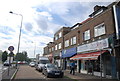
5
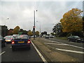
Great West Road at the junction of Bath Road
Image: © David Howard
Taken: 21 Oct 2013
0.17 miles
10
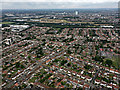
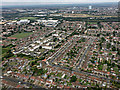
Heston from the air
Springwell Road is prominent, running diagonally from the lower left corner of the photo. Southall gas works can be seen in the distance, beyond Airlinks golf club.
Image: © Thomas Nugent
Taken: 10 Aug 2016
0.20 miles