IMAGES TAKEN NEAR TO
Blackberry Farm Close, HOUNSLOW, TW5 9EH
Introduction
This page details the photographs taken nearby to Blackberry Farm Close, TW5 9EH by members of the Geograph project.
The Geograph project started in 2005 with the aim of publishing, organising and preserving representative images for every square kilometre of Great Britain, Ireland and the Isle of Man.

There are currently over 7.5m images from over14,400 individuals and you can help contribute to the project by visiting https://www.geograph.org.uk
Image Map
Images are licensed for reuse under creativecommons.org/licenses/by-sa/2.0
Notes
- Clicking on the map will re-center to the selected point.
- The higher the marker number, the further away the image location is from the centre of the postcode.
Image Listing (16 Images Found)
Images are licensed for reuse under creativecommons.org/licenses/by-sa/2.0
Image
Details
Distance
1
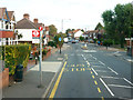
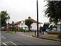
Somerset Waye eastbound bus stop, Heston
On Cranford Lane.
Image: © Robin Webster
Taken: 22 Sep 2012
0.13 miles
2
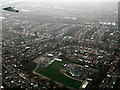
Springwell Junior School from the air
A school with extensive playing fields on Vicarage Farm Road.
Image: © Thomas Nugent
Taken: 21 Dec 2013
0.13 miles
3
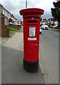
George V postbox on Cranford Lane, Heston
Postbox No. TW5 55.
Image: © JThomas
Taken: 23 May 2022
0.15 miles
7
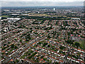
Heston from the air
Springwell Road is prominent, running diagonally from the lower left corner of the photo. Southall gas works can be seen in the distance, beyond Airlinks golf club.
Image: © Thomas Nugent
Taken: 10 Aug 2016
0.16 miles
8
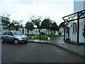
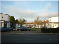
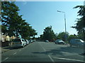
Vicarage Farm Road at the junction of Orchard Avenue
Image: © David Howard
Taken: 17 Aug 2013
0.20 miles
10
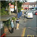
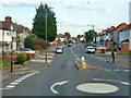
Heston Health Centre bus stop
Towards Hounslow.
Image: © Robin Webster
Taken: 22 Sep 2012
0.20 miles