IMAGES TAKEN NEAR TO
Jersey Road, HOUNSLOW, TW5 0TW
Introduction
This page details the photographs taken nearby to Jersey Road, TW5 0TW by members of the Geograph project.
The Geograph project started in 2005 with the aim of publishing, organising and preserving representative images for every square kilometre of Great Britain, Ireland and the Isle of Man.

There are currently over 7.5m images from over14,400 individuals and you can help contribute to the project by visiting https://www.geograph.org.uk
Image Map
Images are licensed for reuse under creativecommons.org/licenses/by-sa/2.0
Notes
- Clicking on the map will re-center to the selected point.
- The higher the marker number, the further away the image location is from the centre of the postcode.
Image Listing (30 Images Found)
Images are licensed for reuse under creativecommons.org/licenses/by-sa/2.0
Image
Details
Distance
1
Talent Spotting
Brentford FC's Academy training ground, beside Jersey Road.
Image: © Peter Trimming
Taken: 16 Apr 2016
0.02 miles
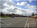
4
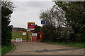
Great West Road
The A4, to the west of Osterley underground station.
Image: © Peter Trimming
Taken: 16 Apr 2016
0.11 miles
5

Osterley - Pevencey Close
Modern terrace housing.
Image: © James Emmans
Taken: 10 Oct 2016
0.11 miles
8
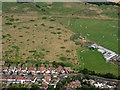
Brentford FC training ground from the air
Off Jersey Road, near Osterley Park.
Image: © Thomas Nugent
Taken: 10 Aug 2016
0.12 miles
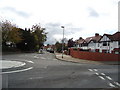
9
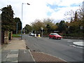
Heston, Hounslow
The junction of Jersey Road and Alderney Avenue.
Image: © Peter Trimming
Taken: 16 Apr 2016
0.12 miles
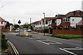
10
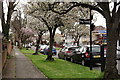
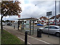
Stucley Road
Spring has arrived at this road, which is located close to Osterley underground station.
Image: © Peter Trimming
Taken: 16 Apr 2016
0.13 miles