IMAGES TAKEN NEAR TO
Lime Tree Road, HOUNSLOW, TW5 0TD
Introduction
This page details the photographs taken nearby to Lime Tree Road, TW5 0TD by members of the Geograph project.
The Geograph project started in 2005 with the aim of publishing, organising and preserving representative images for every square kilometre of Great Britain, Ireland and the Isle of Man.

There are currently over 7.5m images from over14,400 individuals and you can help contribute to the project by visiting https://www.geograph.org.uk
Image Map
Images are licensed for reuse under creativecommons.org/licenses/by-sa/2.0
Notes
- Clicking on the map will re-center to the selected point.
- The higher the marker number, the further away the image location is from the centre of the postcode.
Image Listing (30 Images Found)
Images are licensed for reuse under creativecommons.org/licenses/by-sa/2.0
Image
Details
Distance
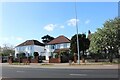
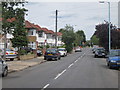
2
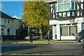
Heston, Hounslow
The junction of Jersey Road with the A4.
Image: © Peter Trimming
Taken: 16 Apr 2016
0.06 miles
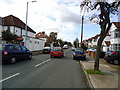
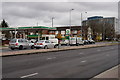
3
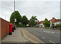
London : Hounslow - Lime Tree Road
Lime Tree Road seen from Great West Road.
Image: © Lewis Clarke
Taken: 20 Oct 2022
0.07 miles
5
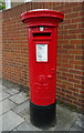
George V postbox on Heston Road, Hounslow
Postbox No. TW5 52.
Image: © JThomas
Taken: 23 May 2022
0.08 miles
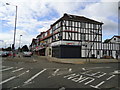
8
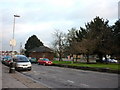
Great West Road
The A4, to the west of Osterley underground station.
Image: © Peter Trimming
Taken: 16 Apr 2016
0.09 miles