IMAGES TAKEN NEAR TO
Heston Road, HOUNSLOW, TW5 0RH
Introduction
This page details the photographs taken nearby to Heston Road, TW5 0RH by members of the Geograph project.
The Geograph project started in 2005 with the aim of publishing, organising and preserving representative images for every square kilometre of Great Britain, Ireland and the Isle of Man.

There are currently over 7.5m images from over14,400 individuals and you can help contribute to the project by visiting https://www.geograph.org.uk
Image Map
Images are licensed for reuse under creativecommons.org/licenses/by-sa/2.0
Notes
- Clicking on the map will re-center to the selected point.
- The higher the marker number, the further away the image location is from the centre of the postcode.
Image Listing (78 Images Found)
Images are licensed for reuse under creativecommons.org/licenses/by-sa/2.0
Image
Details
Distance
1

The Rose & Crown, Heston
There is no indication that it is a tied house.
Image: © Robin Webster
Taken: 22 Sep 2012
0.03 miles
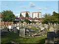
3
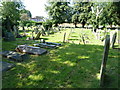
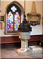
The Parish Church of St Leonard, Heston, Graveyard
Image: © Alexander P Kapp
Taken: 22 Jul 2012
0.06 miles
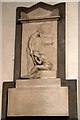
4
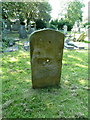
The Parish Church of St Leonard, Heston, Gravestone
Hole in gravestone created by erosion
Image: © Alexander P Kapp
Taken: 22 Jul 2012
0.06 miles
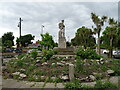
7

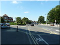
Heston War Memorial
War memorial on the junction of Heston Road and New Heston Road.
Image: © Michael Gibbons
Taken: 15 Aug 2009
0.06 miles