IMAGES TAKEN NEAR TO
Sutton Hall Road, HOUNSLOW, TW5 0PX
Introduction
This page details the photographs taken nearby to Sutton Hall Road, TW5 0PX by members of the Geograph project.
The Geograph project started in 2005 with the aim of publishing, organising and preserving representative images for every square kilometre of Great Britain, Ireland and the Isle of Man.

There are currently over 7.5m images from over14,400 individuals and you can help contribute to the project by visiting https://www.geograph.org.uk
Image Map
Images are licensed for reuse under creativecommons.org/licenses/by-sa/2.0
Notes
- Clicking on the map will re-center to the selected point.
- The higher the marker number, the further away the image location is from the centre of the postcode.
Image Listing (28 Images Found)
Images are licensed for reuse under creativecommons.org/licenses/by-sa/2.0
Image
Details
Distance
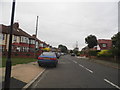

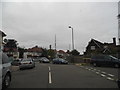
5
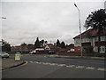
Sutton Road at the junction of Upper Sutton Lane
Image: © David Howard
Taken: 17 Aug 2013
0.09 miles
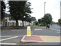
6
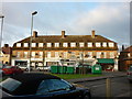
Church Road from The Crossways, Heston
Image: © David Howard
Taken: 17 Aug 2013
0.12 miles
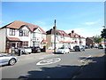
7
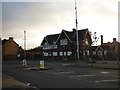
A boarded up pub on Upper Sutton Lane, Heston
Image: © Ian S
Taken: 19 Jan 2011
0.12 miles
9
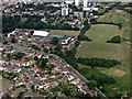
Heston Community School from the air
On the edge of Hounslow http://www.hestoncommunityschool.co.uk/page/default.asp?title=Home&pid=1 .
Image: © Thomas Nugent
Taken: 10 Aug 2016
0.14 miles
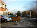
10
The Crossways at the junction of Sutton Way
Image: © David Howard
Taken: 17 Aug 2013
0.14 miles