IMAGES TAKEN NEAR TO
Church Road, HOUNSLOW, TW5 0LA
Introduction
This page details the photographs taken nearby to Church Road, TW5 0LA by members of the Geograph project.
The Geograph project started in 2005 with the aim of publishing, organising and preserving representative images for every square kilometre of Great Britain, Ireland and the Isle of Man.

There are currently over 7.5m images from over14,400 individuals and you can help contribute to the project by visiting https://www.geograph.org.uk
Image Map
Images are licensed for reuse under creativecommons.org/licenses/by-sa/2.0
Notes
- Clicking on the map will re-center to the selected point.
- The higher the marker number, the further away the image location is from the centre of the postcode.
Image Listing (79 Images Found)
Images are licensed for reuse under creativecommons.org/licenses/by-sa/2.0
Image
Details
Distance
1
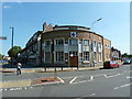
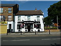
Hounslow Seventhday Adventist Church
It looks very much like it was originally built as a bank
Image: © Alexander P Kapp
Taken: 22 Jul 2012
0.07 miles
2
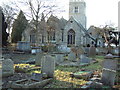
St Leonard, Heston
The graveyard is much more extensive than this photograph is able to show. Apparently the last British soldier to die of flogging is buried somewhere here whilst the famous naturalist, Sir Joseph Banks, lies safely inside the church.
Image: © David Squire
Taken: 11 Jan 2006
0.07 miles
3
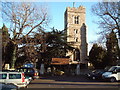
St Leonard, Heston
Once an agricultural parish, Heston is now a typical suburban area of London. The M4 lies only about 500 metres to the north but the church and its rather large surrounding graveyard is surprisingly peaceful.
Image: © David Squire
Taken: 11 Jan 2006
0.07 miles
4
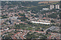
London : Hounslow - City Scenery
Looking down towards the London suburbs from an inbound plane to Heathrow.
Image: © Lewis Clarke
Taken: 6 Sep 2016
0.09 miles
9
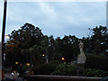
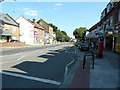
War memorial at the end of New Heston Road
Image: © David Howard
Taken: 13 Oct 2013
0.12 miles
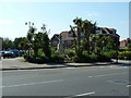
10
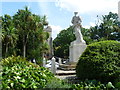
Heston War Memorial and St Leonard's Church tower
In Elizabethan times, Heston was rich farmland, famous for its wheat. In the 19th century it became a centre for brick making and it was said that much of London was built of Heston brown brick.
St Leonard's Church was rebuilt in 1856 but the tower dates from the 15th century. The tower can be seen beyond the war memorial which is on an island at the junction of Heston Road and New Heston Road.
Image: © Marathon
Taken: 7 Aug 2014
0.12 miles