IMAGES TAKEN NEAR TO
Windsor Road, HOUNSLOW, TW4 7QQ
Introduction
This page details the photographs taken nearby to Windsor Road, TW4 7QQ by members of the Geograph project.
The Geograph project started in 2005 with the aim of publishing, organising and preserving representative images for every square kilometre of Great Britain, Ireland and the Isle of Man.

There are currently over 7.5m images from over14,400 individuals and you can help contribute to the project by visiting https://www.geograph.org.uk
Image Map
Images are licensed for reuse under creativecommons.org/licenses/by-sa/2.0
Notes
- Clicking on the map will re-center to the selected point.
- The higher the marker number, the further away the image location is from the centre of the postcode.
Image Listing (27 Images Found)
Images are licensed for reuse under creativecommons.org/licenses/by-sa/2.0
Image
Details
Distance

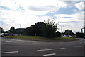
4
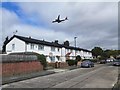
Woodfield Road, Hounslow
A feeder road for housing to the west of the A312, and running closely parallel with it.
Image: © Robin Webster
Taken: 22 Sep 2012
0.09 miles
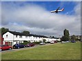
7
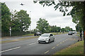
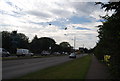
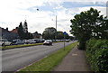
The A4 west of Hounslow
Bath Road is under the flightpath of Heathrow Airport.
Image: © Bill Boaden
Taken: 26 May 2022
0.17 miles
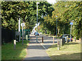
9
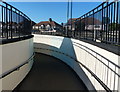
Pedestrian underpass at the Waggoners Roundabout
Image: © Mat Fascione
Taken: 21 Aug 2015
0.17 miles