IMAGES TAKEN NEAR TO
Travellers Way, HOUNSLOW, TW4 7QB
Introduction
This page details the photographs taken nearby to Travellers Way, TW4 7QB by members of the Geograph project.
The Geograph project started in 2005 with the aim of publishing, organising and preserving representative images for every square kilometre of Great Britain, Ireland and the Isle of Man.

There are currently over 7.5m images from over14,400 individuals and you can help contribute to the project by visiting https://www.geograph.org.uk
Image Map
Images are licensed for reuse under creativecommons.org/licenses/by-sa/2.0
Notes
- Clicking on the map will re-center to the selected point.
- The higher the marker number, the further away the image location is from the centre of the postcode.
Image Listing (30 Images Found)
Images are licensed for reuse under creativecommons.org/licenses/by-sa/2.0
Image
Details
Distance
1
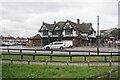
The former Travellers Friend
Once a pub facing Henlys Roundabout, it is now a McDonald's.
Image: © Bill Boaden
Taken: 26 May 2022
0.06 miles
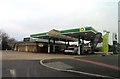
5
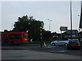
A4/A30 roundabout, Hounslow
The roundabout where the A4 (Great West Road) meets the A30 (Great South West Road) in Hounslow, taken from the BP garage.
And is my 250th pictured gridsquare.
Image: © Phillip Perry
Taken: 21 Sep 2008
0.12 miles
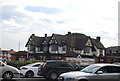
6
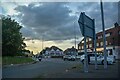
Cranford : Henlys Roundabout A4
Looking towards the roundabout from Bath Road.
Image: © Lewis Clarke
Taken: 27 Jun 2022
0.12 miles
7
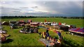
Hounslow Fairground in May 2014 -from the ferris wheel
This fairground popped up in the large open area between the A4 and The Parkway in May 2014. It had just stopped raining heavily and the sky was clearing. Note the long uncut grass between the rides. The price was about £6 per person with unlimited rides.
Image: © Ian
Taken: 24 May 2014
0.13 miles
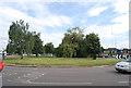
9
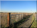
Footpath beside a field
The blank space on the map just here is farmland. Not exactly typical land use for suburban West London, but there are two or three fields still growing crops.
This path runs along the edge.
Image: © Des Blenkinsopp
Taken: 29 Nov 2016
0.13 miles
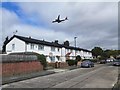
10
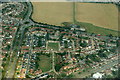
Hounslow West from the air
Taken just after take-off from Heathrow.
Image: © Mike Pennington
Taken: 31 Aug 2018
0.13 miles