IMAGES TAKEN NEAR TO
Great South West Road, HOUNSLOW, TW4 7NH
Introduction
This page details the photographs taken nearby to Great South West Road, TW4 7NH by members of the Geograph project.
The Geograph project started in 2005 with the aim of publishing, organising and preserving representative images for every square kilometre of Great Britain, Ireland and the Isle of Man.

There are currently over 7.5m images from over14,400 individuals and you can help contribute to the project by visiting https://www.geograph.org.uk
Image Map
Images are licensed for reuse under creativecommons.org/licenses/by-sa/2.0
Notes
- Clicking on the map will re-center to the selected point.
- The higher the marker number, the further away the image location is from the centre of the postcode.
Image Listing (22 Images Found)
Images are licensed for reuse under creativecommons.org/licenses/by-sa/2.0
Image
Details
Distance
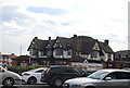
1
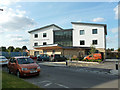
The Meadows Centre for Health
Looking a rather new building, on Chinchilla Drive.
Image: © Robin Webster
Taken: 22 Sep 2012
0.05 miles
2
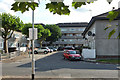
Musquash Way, Hounslow
You must squash into Musquash Way!
Image: © Robin Webster
Taken: 22 Sep 2012
0.10 miles
6
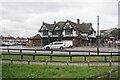
The former Travellers Friend
Once a pub facing Henlys Roundabout, it is now a McDonald's.
Image: © Bill Boaden
Taken: 26 May 2022
0.16 miles
7
The Good Shepherd, Beavers Lane, Hounslow, Mx TW4 6HJ - East end
Image: © John Salmon
Taken: 27 Feb 2008
0.18 miles
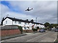
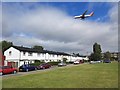
8
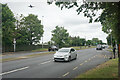
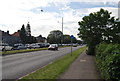
The A4 west of Hounslow
Bath Road is under the flightpath of Heathrow Airport.
Image: © Bill Boaden
Taken: 26 May 2022
0.19 miles
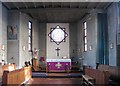
10
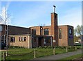
The Good Shepherd, Beavers Lane, Hounslow, Mx TW4 6HJ
Image: © John Salmon
Taken: 27 Feb 2008
0.19 miles