IMAGES TAKEN NEAR TO
Rosemary Avenue, HOUNSLOW, TW4 7JW
Introduction
This page details the photographs taken nearby to Rosemary Avenue, TW4 7JW by members of the Geograph project.
The Geograph project started in 2005 with the aim of publishing, organising and preserving representative images for every square kilometre of Great Britain, Ireland and the Isle of Man.

There are currently over 7.5m images from over14,400 individuals and you can help contribute to the project by visiting https://www.geograph.org.uk
Image Map
Images are licensed for reuse under creativecommons.org/licenses/by-sa/2.0
Notes
- Clicking on the map will re-center to the selected point.
- The higher the marker number, the further away the image location is from the centre of the postcode.
Image Listing (39 Images Found)
Images are licensed for reuse under creativecommons.org/licenses/by-sa/2.0
Image
Details
Distance
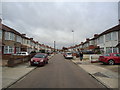
4
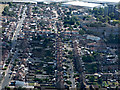
Hounslow West from the air
Looking along Legrace Avenue towards the industrial units at Beavers Lane.
Image: © Thomas Nugent
Taken: 22 Jun 2015
0.10 miles
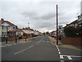
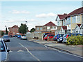
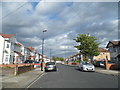
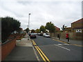
7
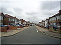
Francis Road, Hounslow
Crossing Manor Avenue in the foreground.
Image: © Robin Webster
Taken: 22 Sep 2012
0.12 miles
10

Old Milepost by the A3006, Bath Road, Hounslow parish
Cast iron post by the A3006, in parish of HOUNSLOW (HOUNSLOW District), in 1973 was near Traveller's Friend on Bath Road, near Manor Gardens, now in private Garden on 1/2 Pevensey Close (by No. 109 Jersey Road). Middlesex cast iron, erected by the Colnbrook, Datchet & Slough turnpike trust in the 19th century.
GR shown is the official O.S.location, not necessarily where the photo was taken.
Inscription reads:-
: COLNBROOK / 6 : : LONDON / 11 / HESTON / PARISH : : HOUNSLOW / 1 :
Milestone Society National ID: MX_LB11.
Image: © C Woodward
Taken: 1 Jan 2002
0.16 miles