IMAGES TAKEN NEAR TO
Hussars Close, HOUNSLOW, TW4 7HJ
Introduction
This page details the photographs taken nearby to Hussars Close, TW4 7HJ by members of the Geograph project.
The Geograph project started in 2005 with the aim of publishing, organising and preserving representative images for every square kilometre of Great Britain, Ireland and the Isle of Man.

There are currently over 7.5m images from over14,400 individuals and you can help contribute to the project by visiting https://www.geograph.org.uk
Image Map
Images are licensed for reuse under creativecommons.org/licenses/by-sa/2.0
Notes
- Clicking on the map will re-center to the selected point.
- The higher the marker number, the further away the image location is from the centre of the postcode.
Image Listing (74 Images Found)
Images are licensed for reuse under creativecommons.org/licenses/by-sa/2.0
Image
Details
Distance
8
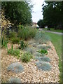
In Beaversfield Park
This view looks towards the entrance from Ravensdale Road. The playground is to the left.
Image: © Marathon
Taken: 17 Aug 2011
0.13 miles
9
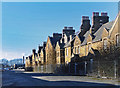
Derelict Houses at Cavalry Barracks
Cavalry Barracks is a largely Victorian military site in the middle of suburban Hounslow. Still partly in use, but scheduled to close in 2020. https://en.wikipedia.org/wiki/Cavalry_Barracks,_Hounslow
Image: © Des Blenkinsopp
Taken: 28 Jan 2019
0.14 miles