IMAGES TAKEN NEAR TO
Standard Road, HOUNSLOW, TW4 7AS
Introduction
This page details the photographs taken nearby to Standard Road, TW4 7AS by members of the Geograph project.
The Geograph project started in 2005 with the aim of publishing, organising and preserving representative images for every square kilometre of Great Britain, Ireland and the Isle of Man.

There are currently over 7.5m images from over14,400 individuals and you can help contribute to the project by visiting https://www.geograph.org.uk
Image Map
Images are licensed for reuse under creativecommons.org/licenses/by-sa/2.0
Notes
- Clicking on the map will re-center to the selected point.
- The higher the marker number, the further away the image location is from the centre of the postcode.
Image Listing (63 Images Found)
Images are licensed for reuse under creativecommons.org/licenses/by-sa/2.0
Image
Details
Distance
1
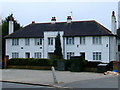
Noel Court
Apartment block on Bath Road, Hounslow.
Image: © Thomas Nugent
Taken: 21 Feb 2011
0.06 miles
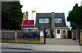
3
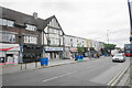
Row of shops on Bath Road
There is a variety of outlets in this row.
Image: © Bill Boaden
Taken: 26 May 2022
0.10 miles
5
Brahma Kumaris University
World Spiritual University UK on Bath Road.
Image: © Thomas Nugent
Taken: 21 Feb 2011
0.12 miles
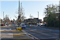
6
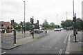
Crossroads on Bath Road
The A3006 is crossed by the A3063 which is a western ring road for Hounslow.
Image: © Bill Boaden
Taken: 26 May 2022
0.12 miles
7
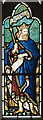
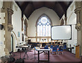
St Paul, Hounslow West - Stained glass window
Image: © John Salmon
Taken: 24 May 2017
0.12 miles
9
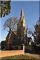
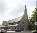
Church of St Paul
Grade II listed. https://historicengland.org.uk/listing/the-list/list-entry/1245132
Image: © N Chadwick
Taken: 2 Dec 2019
0.13 miles