IMAGES TAKEN NEAR TO
Field Close, HOUNSLOW, TW4 6LN
Introduction
This page details the photographs taken nearby to Field Close, TW4 6LN by members of the Geograph project.
The Geograph project started in 2005 with the aim of publishing, organising and preserving representative images for every square kilometre of Great Britain, Ireland and the Isle of Man.

There are currently over 7.5m images from over14,400 individuals and you can help contribute to the project by visiting https://www.geograph.org.uk
Image Map
Images are licensed for reuse under creativecommons.org/licenses/by-sa/2.0
Notes
- Clicking on the map will re-center to the selected point.
- The higher the marker number, the further away the image location is from the centre of the postcode.
Image Listing (35 Images Found)
Images are licensed for reuse under creativecommons.org/licenses/by-sa/2.0
Image
Details
Distance
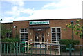
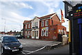
1
Shops on Bath Road Hounslow
A little Victorian shopping parade by Cranford Library.
Image: © David Howard
Taken: 16 Nov 2009
0.05 miles
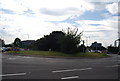
2
Jolly Waggonners, A4
A large roadside pub and eatery.
Image: © N Chadwick
Taken: 25 Jul 2011
0.05 miles
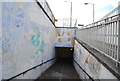
3
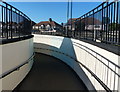
Pedestrian underpass at the Waggoners Roundabout
Image: © Mat Fascione
Taken: 21 Aug 2015
0.05 miles
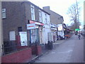
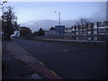
4
A4 Bath Road
Looking east by Cranford library.
Image: © David Howard
Taken: 16 Nov 2009
0.07 miles
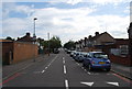
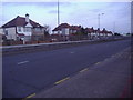
5
A4 Hounslow
Bath Road looking west towards Cranford.
Image: © David Howard
Taken: 16 Nov 2009
0.07 miles
7
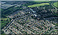
Cranford from the air
The A4 Bath Road Travelodge and HSBC building are prominent.
Image: © Thomas Nugent
Taken: 19 May 2014
0.07 miles