IMAGES TAKEN NEAR TO
Pulborough Way, HOUNSLOW, TW4 6DE
Introduction
This page details the photographs taken nearby to Pulborough Way, TW4 6DE by members of the Geograph project.
The Geograph project started in 2005 with the aim of publishing, organising and preserving representative images for every square kilometre of Great Britain, Ireland and the Isle of Man.

There are currently over 7.5m images from over14,400 individuals and you can help contribute to the project by visiting https://www.geograph.org.uk
Image Map
Images are licensed for reuse under creativecommons.org/licenses/by-sa/2.0
Notes
- Clicking on the map will re-center to the selected point.
- The higher the marker number, the further away the image location is from the centre of the postcode.
Image Listing (34 Images Found)
Images are licensed for reuse under creativecommons.org/licenses/by-sa/2.0
Image
Details
Distance
1
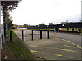
Pulborough Way, Hounslow
On the Green Lane industrial estate
Image: © David Howard
Taken: 27 Oct 2013
0.07 miles
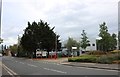
2
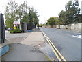
Green Lane, Hounslow
Virgin Atlantic's offices are on the left
Image: © David Howard
Taken: 27 Oct 2013
0.08 miles
4
Skynet Express, Green Lane, Hounslow
Worldwide couriers
Image: © David Howard
Taken: 12 Aug 2018
0.08 miles
5
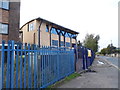
Tarbiyyah Primary School on Green Lane, Hounslow
Image: © David Howard
Taken: 27 Oct 2013
0.08 miles

7
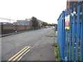
Tamian Way, Hounslow
Part of the Green Lane industrial estate
Image: © David Howard
Taken: 27 Oct 2013
0.09 miles
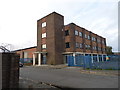
8
Pulborough Way industrial estate, Hounslow
Image: © David Howard
Taken: 12 Aug 2018
0.09 miles
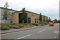
10
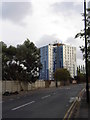
Clements Court from Green Lane, Hounslow
There are many similar blocks across the borough, this is one of the smaller ones.
Image: © David Howard
Taken: 27 Oct 2013
0.11 miles