IMAGES TAKEN NEAR TO
Curtis Road, HOUNSLOW, TW4 5PT
Introduction
This page details the photographs taken nearby to Curtis Road, TW4 5PT by members of the Geograph project.
The Geograph project started in 2005 with the aim of publishing, organising and preserving representative images for every square kilometre of Great Britain, Ireland and the Isle of Man.

There are currently over 7.5m images from over14,400 individuals and you can help contribute to the project by visiting https://www.geograph.org.uk
Image Map
Images are licensed for reuse under creativecommons.org/licenses/by-sa/2.0
Notes
- Clicking on the map will re-center to the selected point.
- The higher the marker number, the further away the image location is from the centre of the postcode.
Image Listing (26 Images Found)
Images are licensed for reuse under creativecommons.org/licenses/by-sa/2.0
Image
Details
Distance
1
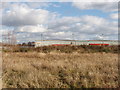
Royal Mail depot by Hounslow Heath
Taken looking east across heathland - which on the 1940s map was railway sidings.
Image: © David Hawgood
Taken: 20 Jan 2006
0.10 miles
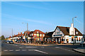
5
Duke of York public house
On Hanworth Road, Hanworth.
Image: © Ian S
Taken: 2 Apr 2022
0.12 miles