IMAGES TAKEN NEAR TO
Staines Road, HOUNSLOW, TW4 5AB
Introduction
This page details the photographs taken nearby to Staines Road, TW4 5AB by members of the Geograph project.
The Geograph project started in 2005 with the aim of publishing, organising and preserving representative images for every square kilometre of Great Britain, Ireland and the Isle of Man.

There are currently over 7.5m images from over14,400 individuals and you can help contribute to the project by visiting https://www.geograph.org.uk
Image Map
Images are licensed for reuse under creativecommons.org/licenses/by-sa/2.0
Notes
- Clicking on the map will re-center to the selected point.
- The higher the marker number, the further away the image location is from the centre of the postcode.
Image Listing (43 Images Found)
Images are licensed for reuse under creativecommons.org/licenses/by-sa/2.0
Image
Details
Distance
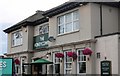
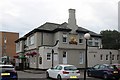
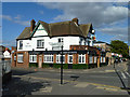
3
The Honeycombe, Staines Road
This seems to be on the site of a pub called The George the Fourth in Victorian times, although possibly not the same building.
Image: © Robin Webster
Taken: 14 Sep 2012
0.06 miles
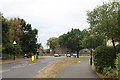
7
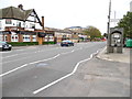
Staines Road, Hounslow
Looking towards The Hussar public house
Image: © David Howard
Taken: 27 Oct 2013
0.09 miles
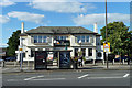
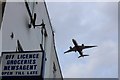
10
The Hussar, Hounslow
Rebuilt 1933, according to the inscription.
Image: © Robin Webster
Taken: 14 Sep 2012
0.09 miles