IMAGES TAKEN NEAR TO
Charles Street, HOUNSLOW, TW3 4LW
Introduction
This page details the photographs taken nearby to Charles Street, TW3 4LW by members of the Geograph project.
The Geograph project started in 2005 with the aim of publishing, organising and preserving representative images for every square kilometre of Great Britain, Ireland and the Isle of Man.

There are currently over 7.5m images from over14,400 individuals and you can help contribute to the project by visiting https://www.geograph.org.uk
Image Map
Images are licensed for reuse under creativecommons.org/licenses/by-sa/2.0
Notes
- Clicking on the map will re-center to the selected point.
- The higher the marker number, the further away the image location is from the centre of the postcode.
Image Listing (82 Images Found)
Images are licensed for reuse under creativecommons.org/licenses/by-sa/2.0
Image
Details
Distance
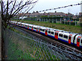
1
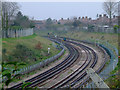
The Piccadilly Line
Curving away from Sutton Lane bridge towards Hounslow West station.
Image: © Thomas Nugent
Taken: 21 Feb 2011
0.08 miles
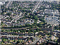
2
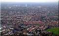
Hounslow from the air
The distinctive shape of Hounslow West underground station, with three red double decker buses outside on Bath Road, can be seen near the lower left corner. The gas holder in the distance is at Southall.
Image: © Thomas Nugent
Taken: 24 Jan 2011
0.10 miles
3
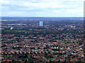
West Hounslow from the air
The gas holder is beyond the M4 motorway at Southall. Viewed from a Heathrow bound flight from Glasgow.
Image: © Thomas Nugent
Taken: 29 Aug 2011
0.10 miles
4
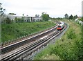
Piccadilly Line in Hounslow
A Cockfosters-bound train rounds the curve from Image to approach the Sutton Lane bridge. The railway dates from 1884 when the Metropolitan District Railway opened their single track branch line to the new Hounslow Barracks station.
Image: © Nigel Cox
Taken: 8 May 2011
0.13 miles
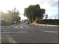
5
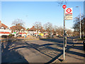
Vicarage Farm Road Bus Stop
The Great West Road in Hounslow.
Image: © Des Blenkinsopp
Taken: 29 Nov 2016
0.14 miles
6
The Piccadilly Line
A Cockfosters bound train passes under the bridge at Sutton Lane, between Hounslow West and Hounslow Central.
Image: © Thomas Nugent
Taken: 21 Feb 2011
0.15 miles
7
Hounslow West from the air
Hounslow West tube station is on the extreme right.
Image: © Thomas Nugent
Taken: 22 Jun 2015
0.15 miles
8
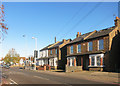
Four Victorian Houses
The development all around is predominantly from the 1930s, but these are older with the year 1898 marked on the wall.
At the junction where Vicarage Farm Road crosses the Great West Road.
Image: © Des Blenkinsopp
Taken: 29 Nov 2016
0.16 miles
9
Wesley Avenue at the junction of Sutton Lane
Image: © David Howard
Taken: 16 Aug 2014
0.17 miles
10
Hounslow Indoor Bowling Club
Off Sutton Lane.
Image: © Thomas Nugent
Taken: 21 Feb 2011
0.17 miles