IMAGES TAKEN NEAR TO
Ellerdine Road, HOUNSLOW, TW3 2PS
Introduction
This page details the photographs taken nearby to Ellerdine Road, TW3 2PS by members of the Geograph project.
The Geograph project started in 2005 with the aim of publishing, organising and preserving representative images for every square kilometre of Great Britain, Ireland and the Isle of Man.

There are currently over 7.5m images from over14,400 individuals and you can help contribute to the project by visiting https://www.geograph.org.uk
Image Map
Images are licensed for reuse under creativecommons.org/licenses/by-sa/2.0
Notes
- Clicking on the map will re-center to the selected point.
- The higher the marker number, the further away the image location is from the centre of the postcode.
Image Listing (7 Images Found)
Images are licensed for reuse under creativecommons.org/licenses/by-sa/2.0
Image
Details
Distance
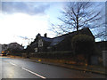
1
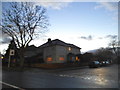
Hall Road at the corner of Eaton Road, Isleworth
Image: © David Howard
Taken: 25 Jan 2014
0.09 miles
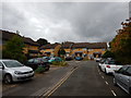
3
Farnell Road at the junction of Worton Road
Image: © David Howard
Taken: 27 Apr 2013
0.16 miles
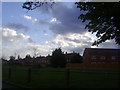
4
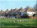
Birds on the Lawn
A small strip of park along the west side of Farnell Road.
Image: © Des Blenkinsopp
Taken: 8 Jan 2019
0.16 miles
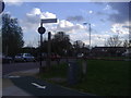
7
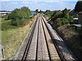
Hounslow to Isleworth railway line
The section of railway line between Hounslow and Isleworth stations is dead straight. This view was taken from the footbridge at the end of Stanley Road, looking towards Isleworth and Waterloo.
Image: © Nigel Cox
Taken: 8 Sep 2006
0.25 miles