IMAGES TAKEN NEAR TO
Argyle Avenue, HOUNSLOW, TW3 2LN
Introduction
This page details the photographs taken nearby to Argyle Avenue, TW3 2LN by members of the Geograph project.
The Geograph project started in 2005 with the aim of publishing, organising and preserving representative images for every square kilometre of Great Britain, Ireland and the Isle of Man.

There are currently over 7.5m images from over14,400 individuals and you can help contribute to the project by visiting https://www.geograph.org.uk
Image Map
Images are licensed for reuse under creativecommons.org/licenses/by-sa/2.0
Notes
- Clicking on the map will re-center to the selected point.
- The higher the marker number, the further away the image location is from the centre of the postcode.
Image Listing (8 Images Found)
Images are licensed for reuse under creativecommons.org/licenses/by-sa/2.0
Image
Details
Distance
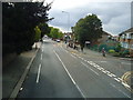
1
London Borough of Hounslow : City Scenery
Looking down towards The Heathland School and Central Mosque.
Image: © Lewis Clarke
Taken: 28 Aug 2018
0.05 miles
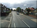
2
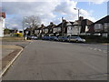
Park Avenue
Park Avenue passing Carrington Avenue
Image: © Shaun Ferguson
Taken: 15 Feb 2013
0.08 miles
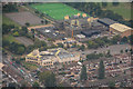
3

Hanworth from the air
The A314, on approach to the south runway at Heathrow from the east.
Image: © Thomas Nugent
Taken: 19 Jun 2015
0.18 miles
5
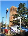
Up the pole, Parkside Road
Fixing the phones, with the tower of St Stephen's Church in the background.
Image: © Des Blenkinsopp
Taken: 8 Jan 2019
0.23 miles
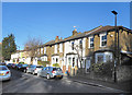
7
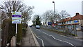
Whitton Road, Approaching Bridge Over Railway at Hounslow Station
Image: © Richard Cooke
Taken: 11 Mar 2018
0.24 miles