IMAGES TAKEN NEAR TO
Livingstone Road, HOUNSLOW, TW3 1XX
Introduction
This page details the photographs taken nearby to Livingstone Road, TW3 1XX by members of the Geograph project.
The Geograph project started in 2005 with the aim of publishing, organising and preserving representative images for every square kilometre of Great Britain, Ireland and the Isle of Man.

There are currently over 7.5m images from over14,400 individuals and you can help contribute to the project by visiting https://www.geograph.org.uk
Image Map
Images are licensed for reuse under creativecommons.org/licenses/by-sa/2.0
Notes
- Clicking on the map will re-center to the selected point.
- The higher the marker number, the further away the image location is from the centre of the postcode.
Image Listing (32 Images Found)
Images are licensed for reuse under creativecommons.org/licenses/by-sa/2.0
Image
Details
Distance
1
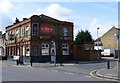
The Lord Clyde Public House Hounslow
The pub is on the corner of Inwood Road and Chapel Road.
Image: © PAUL FARMER
Taken: 28 Mar 2010
0.09 miles
3
Spring Grove from the air
Thornbury Park is prominent.
Image: © Thomas Nugent
Taken: 24 Nov 2014
0.16 miles
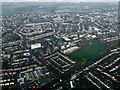
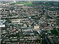
4
Hounslow from the air
Pears Road is in the foreground, Hounslow East tube station is in the centre.
Image: © Thomas Nugent
Taken: 24 Nov 2014
0.16 miles
5
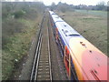
Train on the Hounslow Loop
This view is taken from the footbridge on the footpath between Heath Road and Stanley Road. The bridge in the distance carries Heath Road over the railway and Hounslow station is just beyond.
Image: © Marathon
Taken: 9 Feb 2011
0.17 miles
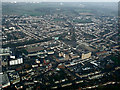
6
Hounslow from the air
Pears Road is in the foreground. The light green patch near the centre is Hounslow East tube station. Hounslow bus garage Image is prominent to the right of centre.
Image: © Thomas Nugent
Taken: 18 Mar 2014
0.18 miles
7
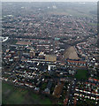
Hounslow from the air
The green roof of Hounslow East tube station is prominent near the centre of the photo. Hounslow bus garage is to the left of the recently cleared brownfield site which is to the right of centre.
Image: © Thomas Nugent
Taken: 16 Feb 2015
0.19 miles
9
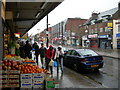
High Street, Hounslow
Looking towards the junction of Hanworth Road.
Image: © Danny P Robinson
Taken: 22 Oct 2006
0.20 miles
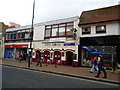
10
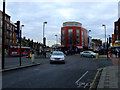
High Street, Hounslow
At the junction with Hanworth Road, which is to the left of the red building which appears to have been recently renovated.
Image: © Thomas Nugent
Taken: 24 Jan 2011
0.20 miles