IMAGES TAKEN NEAR TO
Fairfields Road, HOUNSLOW, TW3 1UY
Introduction
This page details the photographs taken nearby to Fairfields Road, TW3 1UY by members of the Geograph project.
The Geograph project started in 2005 with the aim of publishing, organising and preserving representative images for every square kilometre of Great Britain, Ireland and the Isle of Man.

There are currently over 7.5m images from over14,400 individuals and you can help contribute to the project by visiting https://www.geograph.org.uk
Image Map (Loading...)


Getting Data...Please wait
Leaflet Map data © OpenStreetMap
Images are licensed for reuse under creativecommons.org/licenses/by-sa/2.0
Notes
- Clicking on the map will re-center to the selected point.
- The higher the marker number, the further away the image location is from the centre of the postcode.
Image Listing (110 Images Found)
Images are licensed for reuse under creativecommons.org/licenses/by-sa/2.0
Image
Details
Distance
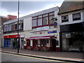
1
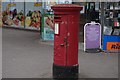
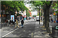
High Street, Hounslow
A colourful scene at the corner of Gilbert Street.
Image: © Thomas Nugent
Taken: 24 Jan 2011
0.04 miles
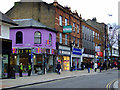
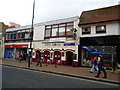
2
High Street, Hounslow
Looking towards the junction with Hanworth Road.
Image: © Thomas Nugent
Taken: 24 Jan 2011
0.05 miles
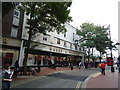
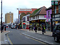
8
High Street, Hounslow
On this section, the road is only available for buses, bicycles and goods deliveries.
Image: © Bill Boaden
Taken: 26 May 2022
0.06 miles
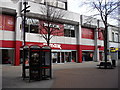
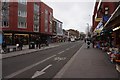
9
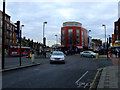
High Street, Hounslow
At the junction with Hanworth Road, which is to the left of the red building which appears to have been recently renovated.
Image: © Thomas Nugent
Taken: 24 Jan 2011
0.07 miles