IMAGES TAKEN NEAR TO
Montague Road, HOUNSLOW, TW3 1LD
Introduction
This page details the photographs taken nearby to Montague Road, TW3 1LD by members of the Geograph project.
The Geograph project started in 2005 with the aim of publishing, organising and preserving representative images for every square kilometre of Great Britain, Ireland and the Isle of Man.

There are currently over 7.5m images from over14,400 individuals and you can help contribute to the project by visiting https://www.geograph.org.uk
Image Map (Loading...)


Getting Data...Please wait
Leaflet Map data © OpenStreetMap
Images are licensed for reuse under creativecommons.org/licenses/by-sa/2.0
Notes
- Clicking on the map will re-center to the selected point.
- The higher the marker number, the further away the image location is from the centre of the postcode.
Image Listing (148 Images Found)
Images are licensed for reuse under creativecommons.org/licenses/by-sa/2.0
Image
Details
Distance
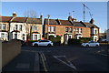
1
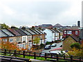
Houses in Montague Road Hounslow
Seen from Hounslow Central Underground Station.
Image: © Rod Allday
Taken: 17 Nov 2014
0.03 miles
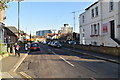
2
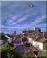
Hounslow
Montague Road in Hounslow seen from Hounslow Central Underground Station.
Image: © Peter McDermott
Taken: 26 May 2011
0.04 miles

5
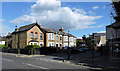
Montague Road at Balfour Road
Balfour Road is in the foreground.
Image: © Thomas Nugent
Taken: 22 Jun 2015
0.04 miles
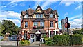
7
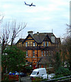
The Bulstrode
Viewed from Hounslow Central station platform, with the obligatory aircraft in the shot.
Image: © Thomas Nugent
Taken: 24 Jan 2011
0.05 miles

10
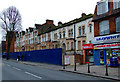
Lampton Road
Boarded-up and screened-off terraced houses awaiting redevelopment. Near Hounslow Central station.
Image: © Thomas Nugent
Taken: 24 Jan 2011
0.06 miles