IMAGES TAKEN NEAR TO
Court Way, TWICKENHAM, TW2 7SA
Introduction
This page details the photographs taken nearby to Court Way, TW2 7SA by members of the Geograph project.
The Geograph project started in 2005 with the aim of publishing, organising and preserving representative images for every square kilometre of Great Britain, Ireland and the Isle of Man.

There are currently over 7.5m images from over14,400 individuals and you can help contribute to the project by visiting https://www.geograph.org.uk
Image Map
Images are licensed for reuse under creativecommons.org/licenses/by-sa/2.0
Notes
- Clicking on the map will re-center to the selected point.
- The higher the marker number, the further away the image location is from the centre of the postcode.
Image Listing (60 Images Found)
Images are licensed for reuse under creativecommons.org/licenses/by-sa/2.0
Image
Details
Distance
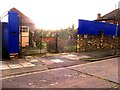
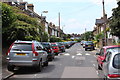
5
![Twickenham on match day [2]](https://s0.geograph.org.uk/geophotos/03/24/63/3246344_a3691bdb_120x120.jpg)
Twickenham on match day [2]
Pop-up souvenir stall at the junction of Whitton Road and Court Way.
Image: © Christine Johnstone
Taken: 1 Dec 2012
0.11 miles
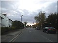
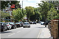
7

Egerton Road / Heathfield South
Shows the location of Image
Image: © Mike Quinn
Taken: 31 Jul 2008
0.12 miles
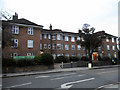
9
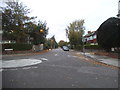
Egerton Road at the junction of Craneford Way
Image: © David Howard
Taken: 25 Oct 2014
0.13 miles
10
![Twickenham on match day [1]](https://s2.geograph.org.uk/geophotos/03/24/63/3246338_6784f783_120x120.jpg)
Twickenham on match day [1]
Crowds walking up Whitton Road for the rugby match. Portable toilets and urinals for their use in Heathfield North.
Image: © Christine Johnstone
Taken: 1 Dec 2012
0.13 miles