IMAGES TAKEN NEAR TO
Whitton Road, TWICKENHAM, TW2 7RE
Introduction
This page details the photographs taken nearby to Whitton Road, TW2 7RE by members of the Geograph project.
The Geograph project started in 2005 with the aim of publishing, organising and preserving representative images for every square kilometre of Great Britain, Ireland and the Isle of Man.

There are currently over 7.5m images from over14,400 individuals and you can help contribute to the project by visiting https://www.geograph.org.uk
Image Map
Images are licensed for reuse under creativecommons.org/licenses/by-sa/2.0
Notes
- Clicking on the map will re-center to the selected point.
- The higher the marker number, the further away the image location is from the centre of the postcode.
Image Listing (75 Images Found)
Images are licensed for reuse under creativecommons.org/licenses/by-sa/2.0
Image
Details
Distance
1
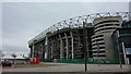
Twickenham from Chase Bridge
View over concrete banked Duke of Northumberland's River to the concrete pile of Twickenham Rugby Ground.
Image: © Colin Smith
Taken: 14 Feb 2008
0.05 miles
2
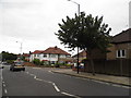
Kneller Road, Whitton
Looking towards Talma Gardens on the right
Image: © David Howard
Taken: 17 Aug 2013
0.06 miles
3
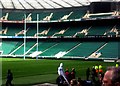
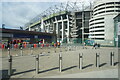
Twickenham stadium - Cup finals day
Whilst not quite the eighty-odd thousand sellout of an international rugby match or a Premiership final, there was still a fantastic atmosphere generated by around five thousand supporters of lower level rugby clubs as they battled out Cup finals at the HQ of English rugby.
In a day of rugby, Harrow played Baildon in the Junior Vase Final, followed by Wells taking on Wath-upon-Dearne in the Senior Vase Final finishing with the RFU Intermediate Cup contested by East Grinstead and Ilkley.
Image: © Ed of the South
Taken: 5 May 2012
0.06 miles
4
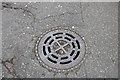
Twickenham Council manhole cover
All the urban and rural district councils were abolished in 1974 with the rearrangement of the British counties. https://en.wikipedia.org/wiki/Urban_district_(Great_Britain_and_Ireland)
Image: © David Howard
Taken: 12 Aug 2018
0.06 miles
6
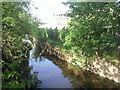
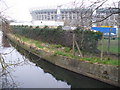
Duke of Northumberland's River, Twickenham
The Duke of Northumberland's River is here seen from Whitton Road, just west of Twickenham Rugby Ground. This section of the Duke of Northumberland's River dates from the time of Syon Abbey and supplied water to the mill at Isleworth and later to the ornamental ponds in the Duke of Northumberland's estate at Syon
Image: © Marathon
Taken: 4 May 2011
0.07 miles
7
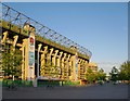
The West Stand, Twickenham Stadium
Seen against the evening sky, from a point close to the Duke of Northumberland's River.
Image: © Stefan Czapski
Taken: 25 May 2014
0.07 miles
9
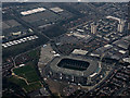
Twickenham Stadium from the air
The home of English rugby, seen shortly after take-off from Heathrow. Mogden sewage works http://en.wikipedia.org/wiki/Mogden_Sewage_Treatment_Works can also be seen.
Image: © Thomas Nugent
Taken: 8 Apr 2015
0.07 miles
10
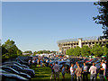
After the game.
Hospitality in the car park.
Image: © Steve Fareham
Taken: 4 Aug 2007
0.07 miles