IMAGES TAKEN NEAR TO
Rosecroft Gardens, TWICKENHAM, TW2 7PT
Introduction
This page details the photographs taken nearby to Rosecroft Gardens, TW2 7PT by members of the Geograph project.
The Geograph project started in 2005 with the aim of publishing, organising and preserving representative images for every square kilometre of Great Britain, Ireland and the Isle of Man.

There are currently over 7.5m images from over14,400 individuals and you can help contribute to the project by visiting https://www.geograph.org.uk
Image Map
Images are licensed for reuse under creativecommons.org/licenses/by-sa/2.0
Notes
- Clicking on the map will re-center to the selected point.
- The higher the marker number, the further away the image location is from the centre of the postcode.
Image Listing (34 Images Found)
Images are licensed for reuse under creativecommons.org/licenses/by-sa/2.0
Image
Details
Distance
1
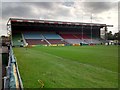
The South Stand at the Twickenham Stoop
Image: © Keith Williams
Taken: 15 May 2015
0.07 miles
2
Former Twickenham Corporation sewage works pump houses
The site is now a rubbish collection services depot, but was formerly a sewage works. A view from the original entrance to the site, now closed and replaced by a route from the north.
Image: © Robin Webster
Taken: 14 Sep 2012
0.10 miles
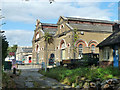
4
Perimeter path, Kneller Gardens
At the corner is a fenced wildflower area.
Image: © Christine Johnstone
Taken: 21 Apr 2015
0.13 miles
5
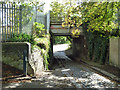
Bridge on Waterloo to Wokingham Junction line
This rather small underpass was formerly the only access to the Twickenham Corporation sewage works, which was behind the camera. The works site is now a rubbish collection services depot, with rather better access from the north.
Image: © Robin Webster
Taken: 14 Sep 2012
0.13 miles
6
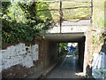
Road with setts and stone flags, Twickenham
Designed for horse-drawn carts. Heading under the railway line to the council depot, which was originally built by Twickenham Urban District Council.
Image: © Christine Johnstone
Taken: 21 Apr 2015
0.13 miles
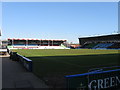
7

The North Stand at the Twickenham Stoop
Image: © Keith Williams
Taken: 15 May 2015
0.13 miles
9
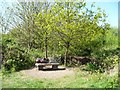
Open space with a wooden fox, off the River Crane Walk
Formerly allotments.
Image: © Christine Johnstone
Taken: 21 Apr 2015
0.14 miles