IMAGES TAKEN NEAR TO
Milner Drive, TWICKENHAM, TW2 7PJ
Introduction
This page details the photographs taken nearby to Milner Drive, TW2 7PJ by members of the Geograph project.
The Geograph project started in 2005 with the aim of publishing, organising and preserving representative images for every square kilometre of Great Britain, Ireland and the Isle of Man.

There are currently over 7.5m images from over14,400 individuals and you can help contribute to the project by visiting https://www.geograph.org.uk
Image Map
Images are licensed for reuse under creativecommons.org/licenses/by-sa/2.0
Notes
- Clicking on the map will re-center to the selected point.
- The higher the marker number, the further away the image location is from the centre of the postcode.
Image Listing (20 Images Found)
Images are licensed for reuse under creativecommons.org/licenses/by-sa/2.0
Image
Details
Distance
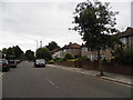
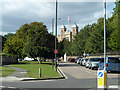
4

Junction of Godfrey Avenue & Alton Gardens
Image: © Richard Cooke
Taken: 11 Mar 2018
0.15 miles
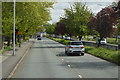
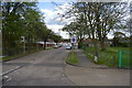
6
Kneller Road
This passes in front of Kneller Hall, a centre for military music.
Image: © Robin Webster
Taken: 14 Sep 2012
0.18 miles
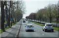
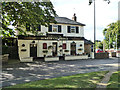
7
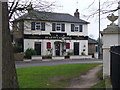
Duke of Cambridge
Large brick-built pub facing Kneller Hall, the Royal Military School of Music.
Image: © Colin Smith
Taken: 14 Feb 2008
0.18 miles
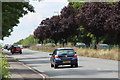
9
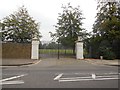
Gates of Kneller Hall
Grounds of the Royal Military School of Music
Image: © Paul Gillett
Taken: 17 Sep 2014
0.19 miles
10
The Duke of Cambridge
On Kneller Road, Twickenham.
Image: © Robin Webster
Taken: 14 Sep 2012
0.19 miles