IMAGES TAKEN NEAR TO
Redway Drive, TWICKENHAM, TW2 7NN
Introduction
This page details the photographs taken nearby to Redway Drive, TW2 7NN by members of the Geograph project.
The Geograph project started in 2005 with the aim of publishing, organising and preserving representative images for every square kilometre of Great Britain, Ireland and the Isle of Man.

There are currently over 7.5m images from over14,400 individuals and you can help contribute to the project by visiting https://www.geograph.org.uk
Image Map
Images are licensed for reuse under creativecommons.org/licenses/by-sa/2.0
Notes
- Clicking on the map will re-center to the selected point.
- The higher the marker number, the further away the image location is from the centre of the postcode.
Image Listing (27 Images Found)
Images are licensed for reuse under creativecommons.org/licenses/by-sa/2.0
Image
Details
Distance
3
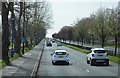
Park near the River Crane in Whitton
This path follows the river Crane (behind the trees to the right) to Hounslow heath and beyond
Image: © steve
Taken: 27 Aug 2005
0.13 miles
4
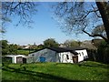
D.E.R.A. Hall, Chertsey Road, Whitton
A social club, available to rent. Does DERA stand for Dene Estate Residents Association?
Image: © Christine Johnstone
Taken: 21 Apr 2015
0.13 miles
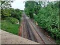
6
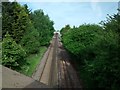
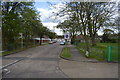
Railway line going towards Whitton Station
The station can be seen in the distance.
Image: © Keith Williams
Taken: 17 May 2015
0.14 miles
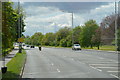
9
Railway line going towards Twickenham Station
Image: © Keith Williams
Taken: 15 May 2015
0.16 miles