IMAGES TAKEN NEAR TO
Hounslow Road, TWICKENHAM, TW2 7HA
Introduction
This page details the photographs taken nearby to Hounslow Road, TW2 7HA by members of the Geograph project.
The Geograph project started in 2005 with the aim of publishing, organising and preserving representative images for every square kilometre of Great Britain, Ireland and the Isle of Man.

There are currently over 7.5m images from over14,400 individuals and you can help contribute to the project by visiting https://www.geograph.org.uk
Image Map
Images are licensed for reuse under creativecommons.org/licenses/by-sa/2.0
Notes
- Clicking on the map will re-center to the selected point.
- The higher the marker number, the further away the image location is from the centre of the postcode.
Image Listing (29 Images Found)
Images are licensed for reuse under creativecommons.org/licenses/by-sa/2.0
Image
Details
Distance
2
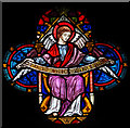
St Philip & St James, Whitton - Stained glass window
Image: © John Salmon
Taken: 29 Mar 2017
0.03 miles
3
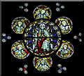
St Philip & St James, Whitton - Stained glass window
Image: © John Salmon
Taken: 29 Mar 2017
0.03 miles
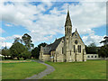
5
St Philip & St James, Whitton - West end
Image: © John Salmon
Taken: 29 Mar 2017
0.03 miles
6
St Philip & St James, Whitton - East end
Image: © John Salmon
Taken: 29 Mar 2017
0.03 miles
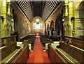
7
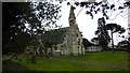
Parish church, Whitton
St Philip and St James has a large churchyard, but apparently not used as a graveyard.
Image: © Robin Webster
Taken: 14 Sep 2012
0.03 miles
8
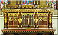
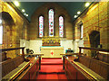
St Philip & St James, Whitton - Reredos
Image: © John Salmon
Taken: 29 Mar 2017
0.03 miles
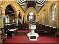
9
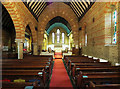
St Philip & St James, Whitton - Chancel
Image: © John Salmon
Taken: 29 Mar 2017
0.03 miles
10
St Philip & St James, Whitton - East end
Image: © John Salmon
Taken: 29 Mar 2017
0.03 miles