IMAGES TAKEN NEAR TO
May Road, TWICKENHAM, TW2 6RJ
Introduction
This page details the photographs taken nearby to May Road, TW2 6RJ by members of the Geograph project.
The Geograph project started in 2005 with the aim of publishing, organising and preserving representative images for every square kilometre of Great Britain, Ireland and the Isle of Man.

There are currently over 7.5m images from over14,400 individuals and you can help contribute to the project by visiting https://www.geograph.org.uk
Image Map
Images are licensed for reuse under creativecommons.org/licenses/by-sa/2.0
Notes
- Clicking on the map will re-center to the selected point.
- The higher the marker number, the further away the image location is from the centre of the postcode.
Image Listing (56 Images Found)
Images are licensed for reuse under creativecommons.org/licenses/by-sa/2.0
Image
Details
Distance
1

Former shop (with ghost sign) at the corner of Colne Road and May Road
In the area between Twickenham Green and the River Crane the urban fabric is all fairly small-scale - mostly terraced housing of various dates, though largely Victorian. Streets are narrow - some of them very narrow.
This former shop is pretty typical of the area (and is one of a number of survivors). The 'ghost sign' seems to read 'Noted Bacon Stores'. More recent occupiers were a firm called Octain Construction.
Image: © Stefan Czapski
Taken: 29 May 2014
0.07 miles
2
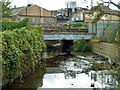
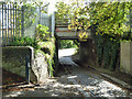
Railway bridge RDG1 3/40
The Waterloo to Wokingham Junction line crosses the River Crane. The Duke of Northumberland's River has taken away most of the water somewhat upstream of this point, hence the rather feeble flow.
Image: © Robin Webster
Taken: 14 Sep 2012
0.11 miles
3
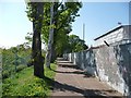
Path between a depot and the railway line, Twickenham
Part of the River Crane Walk.
Image: © Christine Johnstone
Taken: 21 Apr 2015
0.11 miles
4
Pipe bridge on the south side of the railway, Twickenham
Crossing the old access road to the council depot, now the River Crane Way.
Image: © Christine Johnstone
Taken: 21 Apr 2015
0.11 miles
5
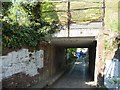
Road with setts and stone flags, Twickenham
Designed for horse-drawn carts. Heading under the railway line to the council depot, which was originally built by Twickenham Urban District Council.
Image: © Christine Johnstone
Taken: 21 Apr 2015
0.12 miles
6
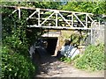
Bridge on Waterloo to Wokingham Junction line
This rather small underpass was formerly the only access to the Twickenham Corporation sewage works, which was behind the camera. The works site is now a rubbish collection services depot, with rather better access from the north.
Image: © Robin Webster
Taken: 14 Sep 2012
0.12 miles
7
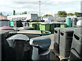
A variety of rubbish bins
In the corner of a large depot for the local rubbish collection services.
Image: © Robin Webster
Taken: 14 Sep 2012
0.12 miles
9
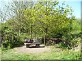
Open space with a wooden fox, off the River Crane Walk
Formerly allotments.
Image: © Christine Johnstone
Taken: 21 Apr 2015
0.14 miles
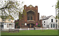
10

The Prince Blucher public house, Twickenham, 1982
The Prince Blucher pub, another of the Fuller's tied estate, pictured in 1982 from across the Staines Road. At the time this was taken, the pub had an unusual bar covered in pre-decimal pennies set in clear resin. Needless to say this war ripped out some time later.
Image: © Stephen Williams
Taken: Unknown
0.15 miles