IMAGES TAKEN NEAR TO
Colne Road, TWICKENHAM, TW2 6QF
Introduction
This page details the photographs taken nearby to Colne Road, TW2 6QF by members of the Geograph project.
The Geograph project started in 2005 with the aim of publishing, organising and preserving representative images for every square kilometre of Great Britain, Ireland and the Isle of Man.

There are currently over 7.5m images from over14,400 individuals and you can help contribute to the project by visiting https://www.geograph.org.uk
Image Map
Images are licensed for reuse under creativecommons.org/licenses/by-sa/2.0
Notes
- Clicking on the map will re-center to the selected point.
- The higher the marker number, the further away the image location is from the centre of the postcode.
Image Listing (45 Images Found)
Images are licensed for reuse under creativecommons.org/licenses/by-sa/2.0
Image
Details
Distance
2
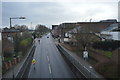
The Dip, Heath Road Twickenham
This is where Heath Road begins at the top of Twickenham Green, and the road dips under the railway line.
Image: © Stephen Williams
Taken: 21 Mar 2007
0.05 miles
4
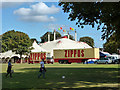
Zippos Circus comes to town
In the corner of Twickenham Green. Rehearsal noises were coming from the big top.
Image: © Robin Webster
Taken: 22 Sep 2012
0.12 miles
5
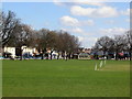
Twickenham Green
This is the cricket pitch on Twickenham Green, looking towards the town centre.
The building in the distance (actually in square Image) is a former public convenience now converted into a trendy bistro.
Image: © Stephen Williams
Taken: 21 Mar 2007
0.12 miles
6

Zippos Circus comes to town
In the corner of Twickenham Green. Rehearsal noises were coming from the big top.
Image: © Robin Webster
Taken: 22 Sep 2012
0.13 miles
7
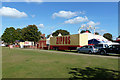
Zippos Circus comes to town
In the corner of Twickenham Green. Rehearsal noises were coming from the big top.
Image: © Robin Webster
Taken: 22 Sep 2012
0.13 miles
8
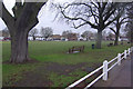
Twickenham Green
What is now Twickenham Green was once part of the extensive Hounslow Heath. It was purchased by the town council in the 19th century, as the area became built up, for public recreation. It is now managed by the Borough of Richmond upon Thames.
Image: © Stephen McKay
Taken: 16 Dec 2010
0.13 miles
9
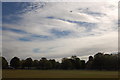
Twickenham Green and Heathrow flightpath
View looking east across the cricket pitch at Twickenham Green whilst a British Airways flight heads off to the continent.
Image: © Roger Davies
Taken: 9 Sep 2009
0.13 miles
10

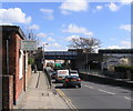
Former shop (with ghost sign) at the corner of Colne Road and May Road
In the area between Twickenham Green and the River Crane the urban fabric is all fairly small-scale - mostly terraced housing of various dates, though largely Victorian. Streets are narrow - some of them very narrow.
This former shop is pretty typical of the area (and is one of a number of survivors). The 'ghost sign' seems to read 'Noted Bacon Stores'. More recent occupiers were a firm called Octain Construction.
Image: © Stefan Czapski
Taken: 29 May 2014
0.14 miles