IMAGES TAKEN NEAR TO
Gostling Road, TWICKENHAM, TW2 6ER
Introduction
This page details the photographs taken nearby to Gostling Road, TW2 6ER by members of the Geograph project.
The Geograph project started in 2005 with the aim of publishing, organising and preserving representative images for every square kilometre of Great Britain, Ireland and the Isle of Man.

There are currently over 7.5m images from over14,400 individuals and you can help contribute to the project by visiting https://www.geograph.org.uk
Image Map
Images are licensed for reuse under creativecommons.org/licenses/by-sa/2.0
Notes
- Clicking on the map will re-center to the selected point.
- The higher the marker number, the further away the image location is from the centre of the postcode.
Image Listing (4 Images Found)
Images are licensed for reuse under creativecommons.org/licenses/by-sa/2.0
Image
Details
Distance
1
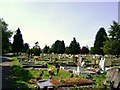
Hounslow Borough Cemetery
A view across an older part of the cemetery.
Image: © Anonymous
Taken: 11 May 2009
0.12 miles
3
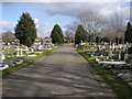
Twickenham Cemetery
Twickenham Cemetery off Hospital Bridge Road
Image: © Shaun Ferguson
Taken: 15 Feb 2013
0.20 miles