IMAGES TAKEN NEAR TO
Ellerman Avenue, TWICKENHAM, TW2 6AR
Introduction
This page details the photographs taken nearby to Ellerman Avenue, TW2 6AR by members of the Geograph project.
The Geograph project started in 2005 with the aim of publishing, organising and preserving representative images for every square kilometre of Great Britain, Ireland and the Isle of Man.

There are currently over 7.5m images from over14,400 individuals and you can help contribute to the project by visiting https://www.geograph.org.uk
Image Map
Images are licensed for reuse under creativecommons.org/licenses/by-sa/2.0
Notes
- Clicking on the map will re-center to the selected point.
- The higher the marker number, the further away the image location is from the centre of the postcode.
Image Listing (50 Images Found)
Images are licensed for reuse under creativecommons.org/licenses/by-sa/2.0
Image
Details
Distance
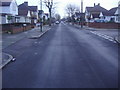
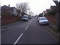
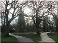
2
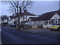
Houses on Ellerman Avenue Whitton
These back on to Crane Park and the river Crane
Image: © David Howard
Taken: 21 Feb 2011
0.05 miles
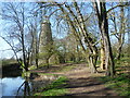
4
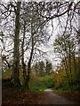
Conker trees in Crane Park
The path runs roughly parallel to the River Crane, though not always close to it. The trees with exposed roots are both horse-chestnuts.
Image: © Stefan Czapski
Taken: 27 Nov 2013
0.08 miles
6
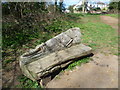
Seat in Crane Park
Crane Park is an attractive linear park following the River Crane in the Boroughs of Hounslow and Richmond upon Thames. The London LOOP passes through part of the park. This attractively-carved seat is near the entrance to the park from Sheringham Avenue.
Image: © Marathon
Taken: 28 Mar 2012
0.09 miles
7
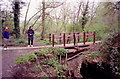
Footbridge next to the shot tower, Crane Park
This wooden footbridge over the Crane was built to make safe a much older brick bridge, the remnants of which can be seen crumbling away below.
Image: © Stephen Williams
Taken: 12 Apr 1992
0.09 miles
8
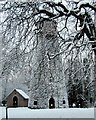
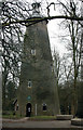
The Shot Tower, Crane Park
This listed building marks the location of gunpowder manufacture on this site for 400 years until the powder mills were closed in 1927.
Image: © Martin Elliff
Taken: 30 Jan 2003
0.11 miles
9
Crane Park Island ? near the entrance
This nature reserve has been described by Sir David Attenborough as “one of Richmond Borough’s best-kept secrets".
Image: © Peter S
Taken: 29 Dec 2015
0.11 miles
10
Crane Park and the Shot Tower
Crane Park is an attractive linear park following the River Crane in the Boroughs of Hounslow and Richmond upon Thames. The London LOOP passes through part of the park. The Shot Tower, standing next to the River Crane, was built in 1823. Its main use was for the production of small lead shot. Molten lead would be poured through a copper sieve from the top of the tower, which at that time was hollow. As the lead fell it formed small round pellets which cooled and hardened as they hit water in a large tank at the bottom of the tower. From 1766 to 1926, the surrounding area was the home to the Hounslow Gunpowder Mills. There were over 55 explosions recorded during the history of the mills, many of them fatal. The Shot Tower and the adjoining Crane Park Island, which is just to the left of the Shot Tower, are now used for environmental education.
Image: © Marathon
Taken: 28 Mar 2012
0.11 miles