IMAGES TAKEN NEAR TO
Ellerman Avenue, TWICKENHAM, TW2 6AF
Introduction
This page details the photographs taken nearby to Ellerman Avenue, TW2 6AF by members of the Geograph project.
The Geograph project started in 2005 with the aim of publishing, organising and preserving representative images for every square kilometre of Great Britain, Ireland and the Isle of Man.

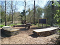
There are currently over 7.5m images from over14,400 individuals and you can help contribute to the project by visiting https://www.geograph.org.uk
Image Map
Images are licensed for reuse under creativecommons.org/licenses/by-sa/2.0
Notes
- Clicking on the map will re-center to the selected point.
- The higher the marker number, the further away the image location is from the centre of the postcode.
Image Listing (32 Images Found)
Images are licensed for reuse under creativecommons.org/licenses/by-sa/2.0
Image
Details
Distance
1
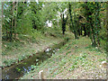
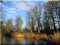
Former mill stream, Hounslow Powder Mills
This is near the end of the lengthy leat that supplied the mills set above the main mill pond. Other mills were powered from the pond at a lower level.
Image: © Robin Webster
Taken: 14 Sep 2012
0.07 miles
2
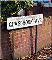
Glasbrook Ave. Borough of Twickenham
Just a bit of nameboard trivia here. Painted out but still obvious on this street name sign is the insignia of the former local authority for this area, the borough of Twickenham.
This ceased as a separate body in 1965, merging into the London borough of Richmond. Facts and figures on http://en.wikipedia.org/wiki/Municipal_Borough_of_Twickenham
Glasbrook is a place near Swansea.
Image: © Des Blenkinsopp
Taken: 13 Nov 2011
0.07 miles
3
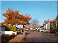
Glasbrook Avenue, Whitton
A typical street for this area, mixed semis and bungalows. Typical sky too with all those cloud trails. Heathrow Airport is just west of here.
Glasbrook is a place near Swansea.
Image: © Des Blenkinsopp
Taken: 13 Nov 2011
0.08 miles
4
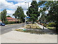
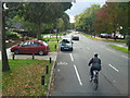
Start of Crane River cycleway to Twickenham
This is A314 Hanworth Road - just in Richmond. From here there is a pleasant walk and cycleway beside the River Crane for two miles to Twickenham, ending through Kneller Gardens to Craneford Road by The Stoop and Richmond Upon Thames College.
Image: © David Hawgood
Taken: 24 Jul 2010
0.08 miles
5
Outdoor classroom, Crane Park
This outdoor classroom in Crane Park would be especially delightful on a glorious day such as this one. It is located in Crane Park, close to Hanworth Road.
Image: © Marathon
Taken: 28 Mar 2012
0.08 miles
6
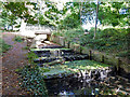
Mill stream cascade
A high level mill stream returns to join the natural course of the River Crane. This is on the site of the old Hounslow Powder Mills, long gone, but leaving an intriguing network of waterways, humps and hollows.
Image: © Robin Webster
Taken: 14 Sep 2012
0.09 miles
7
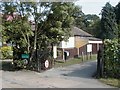
Entrance to Crane Park on Hanworth Road
Image: © Martin Elliff
Taken: 22 Sep 2005
0.09 miles
8
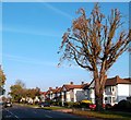
Hanworth Road, Whitton
Apart from the housing, another feature typical of suburban streets is the heavy duty surgery applied to any tree that's getting too big.
This looks like a horse chestnut, already suffering from blight. How much can a tree take?
This is on one of the roadside bits of the London Loop long distance path.
Image: © Des Blenkinsopp
Taken: 13 Nov 2011
0.09 miles
10
Northwestern end of Crane Park
Crane Park Island Nature Reserve is located in the Twickenham area and offers a peaceful haven for wildlife amid London’s suburbia. The island is man-made and is 4.5 acres in size. It is connected to the “mainland” by a short crossing through a gate and a walkway overlooking the river. The site was formerly the location of the Hounslow Gunpowder Mills. The mills used the River Crane as a source of water power.
Image: © Peter S
Taken: 29 Dec 2015
0.10 miles