IMAGES TAKEN NEAR TO
Fifth Cross Road, TWICKENHAM, TW2 5LJ
Introduction
This page details the photographs taken nearby to Fifth Cross Road, TW2 5LJ by members of the Geograph project.
The Geograph project started in 2005 with the aim of publishing, organising and preserving representative images for every square kilometre of Great Britain, Ireland and the Isle of Man.

There are currently over 7.5m images from over14,400 individuals and you can help contribute to the project by visiting https://www.geograph.org.uk
Image Map
Images are licensed for reuse under creativecommons.org/licenses/by-sa/2.0
Notes
- Clicking on the map will re-center to the selected point.
- The higher the marker number, the further away the image location is from the centre of the postcode.
Image Listing (39 Images Found)
Images are licensed for reuse under creativecommons.org/licenses/by-sa/2.0
Image
Details
Distance
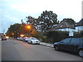
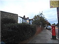
5
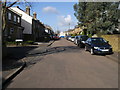
Fourth Cross Road
Fourth Cross Road passing Norwood Close
Image: © Shaun Ferguson
Taken: 15 Feb 2013
0.11 miles
6
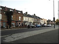
Houses on Staines Road, Twickenham
The Bloomsbury Pub is at the end of the terrace on the right
Image: © David Howard
Taken: 27 Oct 2014
0.13 miles
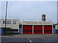
7
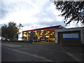
Esso petrol station on Staines Road, Twickenham
Image: © David Howard
Taken: 25 Oct 2014
0.14 miles
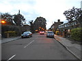
8
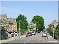
Fifth Cross Road, Fulwell
Fifth Cross Road, photographed from Hampton Road
Image: © Malc McDonald
Taken: 19 May 2010
0.15 miles
10
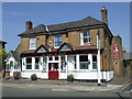
Prince of Wales, Hampton Road
The Prince of Wales pub, on the corner of Hampton Road and Fourth Cross Road
Image: © Malc McDonald
Taken: 19 May 2010
0.17 miles