IMAGES TAKEN NEAR TO
Boshers Gardens, EGHAM, TW20 9NZ
Introduction
This page details the photographs taken nearby to Boshers Gardens, TW20 9NZ by members of the Geograph project.
The Geograph project started in 2005 with the aim of publishing, organising and preserving representative images for every square kilometre of Great Britain, Ireland and the Isle of Man.

There are currently over 7.5m images from over14,400 individuals and you can help contribute to the project by visiting https://www.geograph.org.uk
Image Map
Images are licensed for reuse under creativecommons.org/licenses/by-sa/2.0
Notes
- Clicking on the map will re-center to the selected point.
- The higher the marker number, the further away the image location is from the centre of the postcode.
Image Listing (46 Images Found)
Images are licensed for reuse under creativecommons.org/licenses/by-sa/2.0
Image
Details
Distance
1
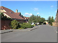
Boshers Garden
The post 2000 estate that now occupies a narrow field that existed between Manor Way and Braywood Avenue. This road is so recent that it is yet to appear on some map editions.
Image: © Alan Hunt
Taken: 19 Sep 2012
0.02 miles
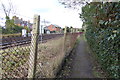
2
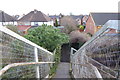
Looking east down steps from railway footbridge
Image: © Shazz
Taken: 21 Feb 2015
0.04 miles
3
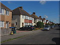
Rusham Park Avenue
The view of Rusham Park Avenue from the footpath that marks the end of the road.
Image: © Alan Hunt
Taken: 19 Sep 2012
0.06 miles
4
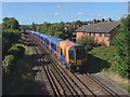
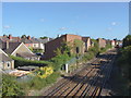
Approaching Egham station
The railway line from the bridge on the footpath from Whitehall Lane to the Ripley Springs area of Egham. The train has just come from Virginia Water, next stop Egham.
Image: © Alan Hunt
Taken: 19 Sep 2012
0.07 miles
5
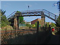
Railway footbridge, Egham
The footbridge over the railway on the footpath that runs from Whitehall Lane to North Street in Egham.
Image: © Alan Hunt
Taken: 19 Sep 2012
0.07 miles
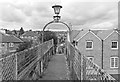
6
Footpath heads towards footbridge over railway
A 2012 picture of the bridge is at http://www.geograph.org.uk/photo/3141492.
Image: © Shazz
Taken: 21 Feb 2015
0.07 miles
7
Railway Footbridge
A footpath crosses the tracks south of Egham station.
Image: © Des Blenkinsopp
Taken: 21 Mar 2017
0.07 miles
8
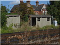
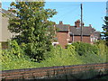
Trackworkers' shelters
Concrete shelters beside the railway line between Egham and Virginia Water. The houses with the notable gable ends are on Rusham Road.
Image: © Alan Hunt
Taken: 19 Sep 2012
0.08 miles
9
Railway, Egham
Looking along the tracks towards Egham station from the bridge on the footpath from Whitehall Lane. The properties on the left are on Rushenden Road.
Image: © Alan Hunt
Taken: 19 Sep 2012
0.08 miles
10
Across the tracks
Looking across the railway line towards the houses on Rusham Road from the footpath that runs alongside the railway down to Prune Hill.
Image: © Alan Hunt
Taken: 19 Sep 2012
0.10 miles