IMAGES TAKEN NEAR TO
Strode Street, EGHAM, TW20 9BT
Introduction
This page details the photographs taken nearby to Strode Street, TW20 9BT by members of the Geograph project.
The Geograph project started in 2005 with the aim of publishing, organising and preserving representative images for every square kilometre of Great Britain, Ireland and the Isle of Man.

There are currently over 7.5m images from over14,400 individuals and you can help contribute to the project by visiting https://www.geograph.org.uk
Image Map
Images are licensed for reuse under creativecommons.org/licenses/by-sa/2.0
Notes
- Clicking on the map will re-center to the selected point.
- The higher the marker number, the further away the image location is from the centre of the postcode.
Image Listing (49 Images Found)
Images are licensed for reuse under creativecommons.org/licenses/by-sa/2.0
Image
Details
Distance
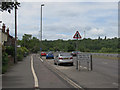
1
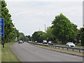
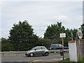
Egham bypass
This stretch of the A30, a dual-carriageway bypass with a 50mph speed limit, was opened in 1935 (source: http://www.sabre-roads.org.uk/wiki/index.php?title=Network_changes_-_1930s ).
Image: © Stephen Craven
Taken: 25 May 2015
0.03 miles
3
Pre-Worboys sign on Hummer Road, Egham
Thanks to Stephen Craven for discovering this, made for the bypass in or since 1935. The pedestrian part has been painted out, presumably as pedestrians can't cross the barrier, but would apply now to all vehicles instead.
Image: © David Howard
Taken: 31 May 2015
0.08 miles
4
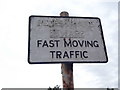
Unusual roadsign, Hummer Road, Egham (closeup)
The old roadsign, at the north end of Hummer Road where it meets the Egham bypass, reads "Pedestrians beware fast moving traffic". It presumably dates from 1935 when the bypass was built (source: http://www.sabre-roads.org.uk/wiki/index.php?title=Network_changes_-_1930s ) The last three words have been picked out in black paint, the first two are now barely legible.
For context, see Image
Image: © Stephen Craven
Taken: 25 May 2015
0.08 miles
5
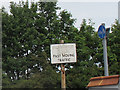
Unusual roadsign, Hummer Road, Egham
The old roadsign, at the north end of Hummer Road where it meets the Egham bypass, reads "Pedestrians beware fast moving traffic". It presumably dates from 1935 when the bypass was built (source: http://www.sabre-roads.org.uk/wiki/index.php?title=Network_changes_-_1930s ) The last three words have been picked out in black paint, the first two are now barely legible.
Image: © Stephen Craven
Taken: 25 May 2015
0.08 miles
6
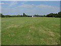
Runnymede meadows
The large open area of Runnymede meadows, owned by the National Trust, looking towards the two gate lodges on the A308 near the Runnymede roundabout. This area is part of the Thames floodplain.
Image: © Alan Hunt
Taken: 9 Aug 2012
0.08 miles
7
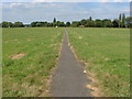
Straight as an arrow
The narrow tarmac path that runs from the A30 to the A308 across the Runnymede meadows.
Image: © Alan Hunt
Taken: 9 Aug 2012
0.10 miles
8
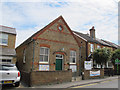
Nursery in former chapel, Hummer Road, Egham
The building is still shown as a place of worship on recent maps. It seems to have been originally a Friends meeting house, later a Plymouth Brethren meeting house. Now it is a children's nursery.
Image: © Stephen Craven
Taken: 25 May 2015
0.11 miles
9
Cycle lane alongside the Egham bypass
This stretch of the A30, a dual-carriageway bypass with a 50mph speed limit, forms part of National Cycle Network route 4, so a segregated cycle lane is pretty mush essential. It follows current good practice by having parking bays between the cycle lane and the traffic lane.
Image: © Stephen Craven
Taken: 25 May 2015
0.11 miles
10
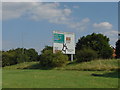
There's the sign, where's the road
The large direction sign on the A30, viewed from the Runnymede meadows. The A30, Egham by-pass, a not insubstantial dual carriageway, is hidden by the banking
Image: © Alan Hunt
Taken: 9 Aug 2012
0.12 miles