IMAGES TAKEN NEAR TO
Helvellyn Close, EGHAM, TW20 8JQ
Introduction
This page details the photographs taken nearby to Helvellyn Close, TW20 8JQ by members of the Geograph project.
The Geograph project started in 2005 with the aim of publishing, organising and preserving representative images for every square kilometre of Great Britain, Ireland and the Isle of Man.

There are currently over 7.5m images from over14,400 individuals and you can help contribute to the project by visiting https://www.geograph.org.uk
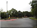
Image Map
Images are licensed for reuse under creativecommons.org/licenses/by-sa/2.0
Notes
- Clicking on the map will re-center to the selected point.
- The higher the marker number, the further away the image location is from the centre of the postcode.
Image Listing (12 Images Found)
Images are licensed for reuse under creativecommons.org/licenses/by-sa/2.0
Image
Details
Distance
1

Footpath, Thorpe Lea
The footbridge over the drain that marks the boundary between Thorpe Lea and Egham Hythe. The footpath runs from Thorpe Lea Road To Ayebridges Avenue.
Image: © Alan Hunt
Taken: 19 Sep 2012
0.07 miles
2

Recreation Area, Thorpe Lea
The small green off Ambleside Way.
Image: © Alan Hunt
Taken: 19 Sep 2012
0.09 miles
3
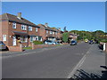
Ayebridges Avenue, Egham Hythe
The view along Ayebridges Avenue, a residential street in Egham Hythe.
Image: © Alan Hunt
Taken: 19 Sep 2012
0.12 miles
4

Thorpe Lea
Wavendene Avenue from its junction with Thorpe Lea Road.
Image: © Alan Hunt
Taken: 19 Sep 2012
0.13 miles
5
Thorpe Lea Road looking towards Wavendene Avenue
Image: © David Howard
Taken: 24 Aug 2013
0.15 miles
6

Derwent Road, Thorpe Lea
Derwent Road, a feeder road for the modern housing estate off Thorpe Lea Road. The estate was built during the 1980s on the former site of Thorpe Lea Nursery.
Image: © Alan Hunt
Taken: 19 Sep 2012
0.15 miles
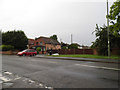
7

Clockhouse Lane East
The junction of Clockhouse Lane East with Thorpe Lea Road. The Clockhouse sits in the crook of the junction. There is a Clockhouse Lane West since the M25 bisected the lane in the 1980s.
Image: © Alan Hunt
Taken: 19 Sep 2012
0.15 miles
8

Thorpe Lea Road
Thorpe Lea Road approaching the junction with New Wickham Lane and Vicarage Road. This part of Thorpe Lea Road is designated the B388, the designation is passed to Vicarage Road while Thorpe Lea Road continues towards Egham Hythe as the B3376. The junction on the right is Derwent Road.
Image: © Alan Hunt
Taken: 19 Sep 2012
0.16 miles
10
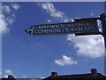
Old style council sign, Warwick Avenue, Egham
This is on the pre-Worboys direction sign format but probably issued by the council as it is for a local building.
Image: © David Howard
Taken: 11 Jul 2010
0.22 miles