IMAGES TAKEN NEAR TO
Hedingham Drive, EGHAM, TW20 0HG
Introduction
This page details the photographs taken nearby to Hedingham Drive, TW20 0HG by members of the Geograph project.
The Geograph project started in 2005 with the aim of publishing, organising and preserving representative images for every square kilometre of Great Britain, Ireland and the Isle of Man.

There are currently over 7.5m images from over14,400 individuals and you can help contribute to the project by visiting https://www.geograph.org.uk
Image Map
Images are licensed for reuse under creativecommons.org/licenses/by-sa/2.0
Notes
- Clicking on the map will re-center to the selected point.
- The higher the marker number, the further away the image location is from the centre of the postcode.
Image Listing (60 Images Found)
Images are licensed for reuse under creativecommons.org/licenses/by-sa/2.0
Image
Details
Distance
1
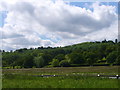
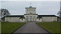
Runnymede and Cooper's Hill
The wide meadow at Runnymede and Cooper's Hill from the Thames Path. The Magna Carta Memorial is on the very left at the bottom of the hill, but is mostly obscured by a tree. The top of the Air Forces Memorial is visible on the left at the top of the hill. For more info see https://www.nationaltrust.org.uk/runnymede-and-ankerwycke
Image: © Sean Davis
Taken: 22 May 2009
0.10 miles
2
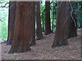
Cooper's Hill Slopes
Stand of giant redwood trees in the woods below the Air Forces Memorial.
Image: © Colin Smith
Taken: 20 Sep 2009
0.12 miles
3
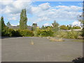
Runnymede Campus, Brunel University
A car park on the now disused Runnymede Campus of Brunel University. The campus was sold a few years ago and is the subject of a planning application to turn it into a care home and private housing.
Image: © Alan Hunt
Taken: 27 Sep 2012
0.14 miles
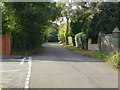
4
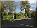
Cooper's Hill Lane
The view along Cooper's Hill Lane with the former Runnymede Campus of Brunel University on the left.
Image: © Alan Hunt
Taken: 27 Sep 2012
0.15 miles
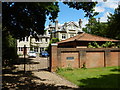
5
Runnymede Campus, Brunel University
One of the buildings of the now disused Runnymede Campus of Brunel University.
Image: © Alan Hunt
Taken: 27 Sep 2012
0.16 miles
6
Cooper's Hill Lane
Cooper's Hill Lane with the junction of Hollycombe on the left.
Image: © Alan Hunt
Taken: 27 Sep 2012
0.17 miles
7
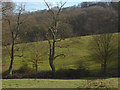
Coopers Hill, Runnymede
Fields on Coopers Hill, part of the National Trust's Runnymede estate.
Image: © Alan Hunt
Taken: 26 Feb 2012
0.18 miles
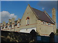
8
Egham - Large House in Coopers Hill Lane
Image: © James Emmans
Taken: 7 Jun 2017
0.18 miles
9
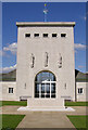
Royal Air Force Memorial, Runnymede, Surrey.
Image: © Kevin Gordon
Taken: 8 Aug 2007
0.19 miles
10
Commonwealth Air Forces memorial, Cooper's Hill, Runnymede
This memorial contains the names of 20,000 British and Commonwealth airmen from WWII with no known graves.
Image: © Andrew Mathewson
Taken: 13 Mar 2010
0.19 miles