IMAGES TAKEN NEAR TO
Buttercup Square, STAINES-UPON-THAMES, TW19 7UD
Introduction
This page details the photographs taken nearby to Buttercup Square, TW19 7UD by members of the Geograph project.
The Geograph project started in 2005 with the aim of publishing, organising and preserving representative images for every square kilometre of Great Britain, Ireland and the Isle of Man.

There are currently over 7.5m images from over14,400 individuals and you can help contribute to the project by visiting https://www.geograph.org.uk
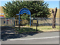
Image Map
Images are licensed for reuse under creativecommons.org/licenses/by-sa/2.0
Notes
- Clicking on the map will re-center to the selected point.
- The higher the marker number, the further away the image location is from the centre of the postcode.
Image Listing (50 Images Found)
Images are licensed for reuse under creativecommons.org/licenses/by-sa/2.0
Image
Details
Distance
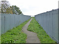
1
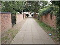
Footpath between Roads
A view of a cut through footpath between Town Lane and Diamedes Avenue in Stanwell in Surrey just east of the Staines Reservoirs.
Image: © John P Reeves
Taken: 13 Sep 2021
0.03 miles
2
Staines reservoir, causeway ramp
The ramp from Town Lane up the embankment to the causeway that carries the public footpath across the middle of the reservoir.
Image: © Alan Hunt
Taken: 1 Aug 2013
0.03 miles
5
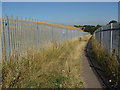
Start of footpath across Staines Reservoirs
The path from Town Lane to Stanwell Moor Road ascends the reservoir bank diagonally.
Image: © Robin Webster
Taken: 22 Oct 2017
0.04 miles
6
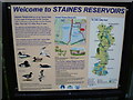
Welcome to Staines Reservoirs
Staines Reservoirs were completed in 1902. This attractive information board in Town Lane, Stanwell is at the entrance to the high level walk between the two Staines Reservoirs - see http://www.geograph.org.uk/photo/4160608
Image: © Marathon
Taken: 10 Sep 2014
0.04 miles
7
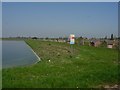
Staines Reservoir
The eastern bank of the north basin. Heathrow terminal 5 is visible just right of the sign. This important area for birds seems to co-exist with the airport, without either significantly affecting the other. The dark spots are some of the huge numbers of flies out on this very warm and calm April morning.
Image: © Hugh Venables
Taken: 15 Apr 2007
0.04 miles
8

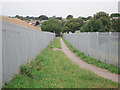
East end of footpath across Staines Reservoirs
The path from Stanwell Moor Road descends the reservoir bank diagonally to open onto Town Lane.
Image: © Robin Webster
Taken: 22 Oct 2017
0.04 miles
9
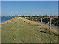
Staines reservoir
The walkway along the top of the embankment with Stanwell to the right.
Image: © Alan Hunt
Taken: 1 Aug 2013
0.05 miles
10
Staines reservoir causeway
The entrance to the causeway that runs across Staines Reservoir on Stanwell's Town Lane
Image: © Alan Hunt
Taken: 1 Aug 2013
0.05 miles